Coder Social home page Coder Social logo

vvoovv / blosm Goto Github PK

View Code? Open in Web Editor NEW
1.4K 74.0 178.0 4.69 MB

Blosm addon for Blender. A few clicks import of Google 3D cities, OpenStreetMap, terrain. Global coverage. Source code is in the branch 'release'.

blender osm openstreetmap addon import terrain google-earth google-maps

blosm's Introduction

Blosm for Blender: OpenStreetMap, Google 3D cities, terrain

Blosm addon for Blender (formerly known as Blender-OSM) provides a few clicks download and import of OpenStreetMap, Google 3D cities and real world terrain data with global coverage. Two versions of the addon are available:

They are briefly described below.

In addition to the features of the base version, the premium one provides:

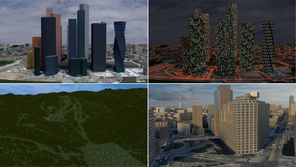
  • Import of buildings from OpenStreetMap with default materials, tileable building textures and UV-mapping applied
  • Default materials and textures to mimic lit windows for a late evening setting
  • Import of forests and single trees as 3D objects
  • Options to use custom tileable building textures (e.g. from textures.com)
  • Satellite imagery and web maps projected on a terrain

Buy the addon at gumroad.com! By purchasing the addon you support the addon development. All customers will get the addon source code under GPL license!

The detailed documentation is available here.

Blosm (the base version)

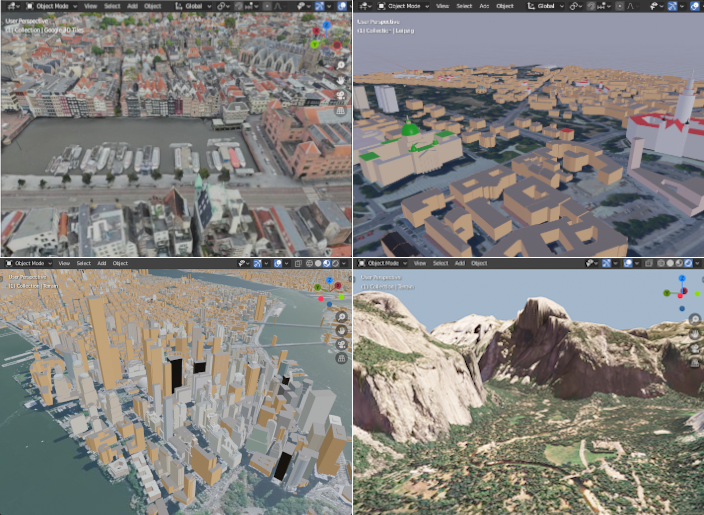
  • blender-osm imports buildings from OpenStreetMap without any texture applied. Building height and number of floors are used to create the final scene. Composition into 3D parts for a building with the complex structure is also processed. A large number of roof shapes is supported. If a terrain is provided, buildings are placed on the terrain automatically.
  • blender-osm downloads and imports real world terrain data with resolution about 30 meter.
  • blender-osm can import GPX-tracks and project them on the terrain.
  • River, lakes, forests, vegetation are imported as polygons. If a terrain is provided, they are projected on the terrain.
  • Imported roads, paths and railways have width. They are represented by Blender curves with a profile object. If a terrain is provided, roads are projected on the terrain.

Get the addon at gumroad.com! You might prefer to pay some price for the addon to support its development. However it is completely optional. The addon source code is available under GPL license!

The detailed documentation is available here.

Links and contacts

blosm's People

Contributors

vvoovv avatar

Stargazers

 avatar  avatar  avatar  avatar  avatar  avatar  avatar  avatar  avatar  avatar  avatar  avatar  avatar  avatar  avatar  avatar  avatar  avatar  avatar  avatar  avatar  avatar  avatar  avatar  avatar  avatar  avatar  avatar  avatar  avatar  avatar  avatar  avatar  avatar  avatar  avatar  avatar  avatar  avatar  avatar  avatar  avatar  avatar  avatar  avatar  avatar  avatar  avatar  avatar  avatar  avatar  avatar  avatar  avatar  avatar  avatar  avatar  avatar  avatar  avatar  avatar  avatar  avatar  avatar  avatar  avatar  avatar  avatar  avatar  avatar  avatar  avatar  avatar  avatar  avatar  avatar  avatar  avatar  avatar  avatar  avatar  avatar  avatar  avatar  avatar  avatar  avatar  avatar  avatar  avatar  avatar  avatar  avatar  avatar  avatar  avatar  avatar  avatar  avatar  avatar

Watchers

 avatar  avatar  avatar  avatar  avatar  avatar  avatar  avatar  avatar  avatar  avatar  avatar  avatar  avatar  avatar  avatar  avatar  avatar  avatar  avatar  avatar  avatar  avatar  avatar  avatar  avatar  avatar  avatar  avatar  avatar  avatar  avatar  avatar  avatar  avatar  avatar  avatar  avatar  avatar  avatar  avatar  avatar  avatar  avatar  avatar  avatar  avatar  avatar  avatar  avatar  avatar  avatar  avatar  avatar  avatar  avatar  avatar  avatar  avatar  avatar  avatar  avatar  avatar  avatar  avatar  avatar  avatar  avatar  avatar  avatar  avatar  avatar  avatar  avatar

blosm's Issues

add a __init__.py and add bl_info

Hi voov,
Would it be possible to put all the files in a folder with an init.py and add the bl_info part at the beginning. Missing bl_info gives bad performances.
Example of bl_info for addons:

bl_info = {
'name': 'blender GEO',
'author': 'Voov',
'version': (1, 0),
'blender': (2, 7, 7),
'location': 'Toolshelf',
'description': 'import OSM etc',
'wiki_url': '',
'tracker_url': '',
'category': 'Import'}

How do I download this?

I have no experience coding but I want to download the OpenStreetMap add-on for Blender and I was directed here to Github. When I open the link it's just code, of which I have no idea to deal with.

About the payment

Hi,sir,
I am really interest in your addon, and i do want to pay for it , but the ploblem is that I am in China, so it is not easy for me to pay this by Paypal ,we often use Alipay for purchase in internet, so ,I want to know if you have Alipay account that I can pay to you.

I can't enable the OSM add-on

Hello there,

I am new to blender and I'm trying to enable my osm add-on.I get this message every time:
screenshot from 2016-11-28 01-21-55

Any ideas?

Can’t enable the add-on: Blender2.78

I could download and install the zip file , but I can’t enable the add-on by checking the enable an add-on. An error message always shows up as followings.

I would be grateful if you could let me know the clue to solve the problem.

errorimage

No menu for the plugin - no buildings when importing osm

I have downloaded the latest zip file and installed it.

When i use it the only choices in the plugin menus are :

  • scale bar
  • in utm coordinates
  • retreive osm tags as vertex groups.

on youtube some made video where we can see other choices:

  • import buildings
  • import natural
    etc...

Is this ok? These choices has disappered?

And when importing an osm file, i see only wires , no buildings surfaces, as seen too on youtube demos.
Why?

Regards.

Error

c

How to overcome this?
Can Anyone Help Me (Blender version 2.78)

Support for barrier=*

Currently any element tagged with barrier=wall or barrier=fence is not imported to blender. I think it would be interesting to import them because they provide interesting 3D information.

Since they are only 2D lines, it may need a text input on import dialog box in order to provide a default value for barriers' thickness. Additionally, each value of barrier key should be imported as different material.

Fails if there isn't active object

Open Blender, select and delete all objects then try to import osm file

line 487, in execute
context.scene.objects.active = context.scene.objects[0]
IndexError: bpy_prop_collection[index]: index 0 out of range, size 0

Interesting data: AHN

The Netherlands has published a very dense elevation map of the entire country in an "open data" program (since 2014). It contains filtered data to describe the terrain without buildings, cars and vegetation and has a precision of 20cm in a grid of 0.5m. The maps are downloadable.

There's another point cloud called "filtered", which is raw data covering all the points that are not considered part of the terrain. So that point cloud covers laser reflections from trees, buildings, cars and bridges.

The two can be used to derive building heights for all buildings in NL established in 2014, even derive the roof type, flat roof constructions like terraces, etc. Since the data is considered open, it may even be allowed to back-update openstreetmap, so that each building has very accurate height information. The "levels" data item remains important, because it can be used to derive the average height per floor and other rendering purposes.

More info and data download: http://nationaalgeoregister.nl/geonetwork/srv/eng/search#|9ca6f842-9482-4f5a-ad87-5307723cfe16

Can't download

Hey vvoovv!
I hope you're still active. I've seen you replying in many forums to your addon.
My problem is simple, I can't reach the download link. Everytime I click on the download link, only a .text file opens in my browser.
Though I would really find your addon amazing. Is there any way to sort it out? Am I just blind or the link is broken for some reason?
Thanks for the great work by the way!

Gabled roofs not working in v2.1.1

I am using newest version 2.1.1 and despite it claims to support most roofs types (amongst them, gabled), and despite having tested with Kremlin sample file (which seems to work perfectly -there's a great job there!), I haven't been able to make it work in my current location.

This is the area I would like to download: http://www.openstreetmap.org/#map=17/41.65534/-0.87817
As you can see from F4.map, roofs are properly tagged, as they are displayed on the simulator (see annotated screenshot below too)

f4map demo interactive 3d map

Unfortunately when importing the osm file into blender, I can't get gabled roofs but flat ones (see screenshot below):
screenshot_20170130_203813

support for roof* tags

According to OSM's wiki on 3D buildings, there are some interesting tags regarding to roofs that may be imported as well, as they dramatically affect the final result of the 3D building:

  • roof:shape (which can be flat, skillion, gabled, half-hipped, hipped, pyramidal, gambrel, mansard, dome, onion,round, saltbox )
  • roof:orientation=along/across
  • roof:direction=*

Additionally, these ones could be considered too:

  • roof:height
  • roof:angle

Memory leak in OSM importer?

Admittedly I am trying to import rather large files from here: https://mapzen.com/data/metro-extracts/

A 200MB OSM file of Sydney - Australia uses 4GB of peak memory and takes too much time. After the import Blender uses only 200MB. So I think there should be some memory leak in the importer.

Now I don't mind the time, but I want to import New York City OSM (2GB) and it is impossible with this much of a memory usage. (It goes up to 10GB and crashes.)

Any ideas? (I don't have much experience with Python but maybe I can help with development.)

add OSM tags as vertex group

Hi vvoovv,
Really great osm importer and really fast. Would it be possible in the "one mesh" mode to have the tags added as vertex groups like in the official blender osm importer? Your plugin is much better, and this functionality would make it perfect :)

SRTM : Nothing loaded in blender 2.76

Hi,

I tried the srtm import module with blender 2.76 and tried to open (several times, playing with the options) a hgt file (N38W113.hgt) from the USGS. I can't see anything in my scene. In blender outliner, I can see a SRTM object, but nothing visible when I select it.
Did I missed a point ?

Import Open Street Map Error

When I attempt to import an .osm file, three perpendicular lines (like axes) appear along with the following error:

screen shot 2016-07-09 at 6 59 31 pm

roads

Do you plan to make road import from *.osm also?

Use UTM to standardize projection

Hi vvoovv,

I've recently needed to refactoring how I handle georeferencing informations in BlenderGIS. Time to talk about compatibility! I know it's already an old discussion and I made no progress last year but its better late than never.

So, I try to match the work already initiate by you and Lukas on dxf importer, especially I've reused the SRID convention to specify the map projection. Here I try to describe more precisely my work.

However my tool is still not completely compatible with blender-geo. In BlenderGIS, it's possible to hack the SRID to pass directly a proj4 string as explained here, so I can include in my tool a special predefined CRS to build the corresponding proj4 string. But I don't specially want to maintain the support of proj4 string, because I think most of the case EPSG codes are enough.

Likewise, I'm not really happy with the solution used in dxf importer, because it specify the custom transverse mercator through a special keyword and, at all, it's not a standard way to define a projection.

So I think maybe a better solution would be to use UTM in blender-geo to standardize the projection and maintain acceptable distortions. Each UTM zone has a dedicated EPSG code : 326xx for north hemisphere and 327xx for south. I think UTM formula is pretty close to the one you actually use but needs some extra code to determine the zone. Maybee there are some helpful functions here.

What do you think ?

Regards

a more detailed complete map?

I tried the latest Add-On, seems like the path extrude is no longer in the option?

Also, with building, etc, is there a suggestion to get a more hires version of buildings, etc? Wondering how much details of the city we can get using this Add-On?

Is there a good thread or blog displaying the whole process?

Building with roof:type=gabled not displaying

Hi!

I'm new to the Simple3DBuildings spec for OSM, so if this is wrong, please feel free to let me know.

I'm attempting to model my house, which is a simple two-part: One part with two levels, one part with one level.

Initially, I simply added two additional ways with a building:part=yes tag; I then added a relation (in a local file, not uploaded to OSM) which attempts to collect them; neither appears to be displaying in Blender.

I've attached an XML file which I'm loading, and would be curious if you have any thoughts on why it might not be working.

I do see that according to the console, it is parsing the building:
Parsing OSM file: 0:00:00.000639
The number of buildings: 1
Processing of parsed OSM data: 0:00:00.000101
Mesh creation in Blender: 0:00:00.000993
Total duration: 0:00:00.001845

And if I remove the building:part s, then it is correctly displaying (but without the multi-level heights, obviously).

Not sure if this is a modelling problem in my OSM, or a tool problem.

Thanks!

myhouse-2.osm.txt

Cannot load some .osm files

Hi, well at first i want to thank you for your addon. I donated today to check 3d capabilities of paid version, but i have a problem in some cases. My .osm files didn't exceed 30MB

In Blender I got this:

Traceback (most recent call last):
  File "C:\Users\G\AppData\Roaming\Blender Foundation\Blender\2.78\scripts\addons\blender-osm\__init__.py", line 172, in execute
    self.process()
  File "C:\Users\G\AppData\Roaming\Blender Foundation\Blender\2.78\scripts\addons\blender-osm\__init__.py", line 203, in process
    m.process()
  File "C:\Users\G\AppData\Roaming\Blender Foundation\Blender\2.78\scripts\addons\blender-osm\building\manager.py", line 110, in process
    building = elements[osmId].b
AttributeError: b

location: <unknown location>:-1

Here is my file:
osm.zip

Georref. Blender Scene - help needed

Hello,

Congratulations for all efforts in comunicate Blender whith mercator rules!

All python modules worked fine, exception for one: Python module transverse_mercator

I cant see this module working inside Blender, in the same way as indicated in preview (site page).

What i am doing wrong?

regards

"blender-osm" licensed under GNU GPL (according Blender rules)

I previously got "blender-geo" (while it was in opensource state), where was only one limitation:

# This is the release version of the plugin file io_import_scene_osm_dev.py
# If you would like to make edits, make them in the file io_import_scene_osm_dev.py and other related modules
# To create the release version of io_import_scene_osm_dev.py execute:
# python plugin_builder.py io_import_scene_osm_dev.py

It had not any copyright restrictions or limitations for forking. So, how I could fork it? Under MIT or so?

Cannot install on Blender 2.73

For some reasons, I must use Blender 2.73. I try to install your zip folder of paid version-'blender-osm' by install from File of User Preferences many times. But still fail. I have followed your installation instruction.
installation problem of openstreetmap addon

Please help!

Recommend Projects

  • React photo React

    A declarative, efficient, and flexible JavaScript library for building user interfaces.

  • Vue.js photo Vue.js

    🖖 Vue.js is a progressive, incrementally-adoptable JavaScript framework for building UI on the web.

  • Typescript photo Typescript

    TypeScript is a superset of JavaScript that compiles to clean JavaScript output.

  • TensorFlow photo TensorFlow

    An Open Source Machine Learning Framework for Everyone

  • Django photo Django

    The Web framework for perfectionists with deadlines.

  • D3 photo D3

    Bring data to life with SVG, Canvas and HTML. 📊📈🎉

Recommend Topics

  • javascript

    JavaScript (JS) is a lightweight interpreted programming language with first-class functions.

  • web

    Some thing interesting about web. New door for the world.

  • server

    A server is a program made to process requests and deliver data to clients.

  • Machine learning

    Machine learning is a way of modeling and interpreting data that allows a piece of software to respond intelligently.

  • Game

    Some thing interesting about game, make everyone happy.

Recommend Org

  • Facebook photo Facebook

    We are working to build community through open source technology. NB: members must have two-factor auth.

  • Microsoft photo Microsoft

    Open source projects and samples from Microsoft.

  • Google photo Google

    Google ❤️ Open Source for everyone.

  • D3 photo D3

    Data-Driven Documents codes.