locationtech / udig-platform Goto Github PK
View Code? Open in Web Editor NEWuDig parent project containing all core components. More plugins can be found in community repos: http://github.com/uDig-Community
Home Page: http://udig.refractions.net
uDig parent project containing all core components. More plugins can be found in community repos: http://github.com/uDig-Community
Home Page: http://udig.refractions.net


![dependabot[bot] avatar](https://avatars.githubusercontent.com/in/29110?v=4 "dependabot[bot]")


From https://ci.eclipse.org/udig/job/uDig-master-CI
Stacktrace:
java.lang.AssertionError: expected:<10> but was:<11>
	at org.junit.Assert.fail(Assert.java:88)
	at org.junit.Assert.failNotEquals(Assert.java:834)
	at org.junit.Assert.assertEquals(Assert.java:645)
	at org.junit.Assert.assertEquals(Assert.java:631)
	at org.locationtech.udig.issues.test.IssuesManagerTest.testRemoveIssues(IssuesManagerTest.java:78)
to $LOCALAPPDATA$/uDig/configuration althought the property is defined only for OS win32 (see features/org.locationtech.udig-product/org.locationtech.udig-product.product).
Expectation : This property is only set on Windows platform
Current behavior: If the content has changed everything in the view is reseted. The typed filter (which may be complex) expression is removed and the user has to type it again and again. After each refresh-event the filter is gone.
Expectation: If the content of a featureCollection changed (e.g. one of MemoryDataStore) the data table should be refreshed while the filter of the table shouldn't.
Maybe it is also possible to keep the filter, if the user switches layer-selection in Layers View and the featuretype is the same.
To reproduce:
!ENTRY org.locationtech.udig.tools.edit 1 0 2019-03-19 11:48:07.169 !MESSAGE !STACK 0 java.lang.NullPointerException: Fid must not be null at org.locationtech.udig.project.command.provider.FIDFeatureProvider.<init>(FIDFeatureProvider.java:33) at org.locationtech.udig.project.internal.commands.edit.SetAttributeCommand.<init>(SetAttributeCommand.java:78) at org.locationtech.udig.project.internal.commands.edit.SetGeometryCommand.<init>(SetGeometryCommand.java:68) at org.locationtech.udig.tools.edit.behaviour.accept.AcceptChangesBehaviour.processIntoCommands(AcceptChangesBehaviour.java:269) at org.locationtech.udig.tools.edit.behaviour.accept.AcceptChangesBehaviour.getCommand(AcceptChangesBehaviour.java:170) at org.locationtech.udig.tools.edit.BehaviourCommand.execute(BehaviourCommand.java:53) at org.locationtech.udig.project.command.CommandManager$Executor.execute(CommandManager.java:395) at org.locationtech.udig.project.command.CommandManager$Executor.run(CommandManager.java:326) at org.locationtech.udig.project.command.CommandManager$Executor.run(CommandManager.java:312) at org.eclipse.core.internal.jobs.Worker.run(Worker.java:56)
reported as https://bugs.eclipse.org/bugs/show_bug.cgi?id=528532
At the moment names of test bundle are not very consitstent. Following the tycho convention it should be *.tests
findings:
An error dialog is displayed when creating a layer if the last used tool was from the "Create" category.
To reproduce:
I think the dialog is erroneous. The new layer is created correctly and the edit tool works as expected.
The modul plugins/org.locationtech.udig.info has several functionalities bundled together and intergators need finer seperation to choose from. E.g. info view and tools might everybody use in an RCP application whereas the documents view and tools not. In addition the measurement tool should be extracted as well ..
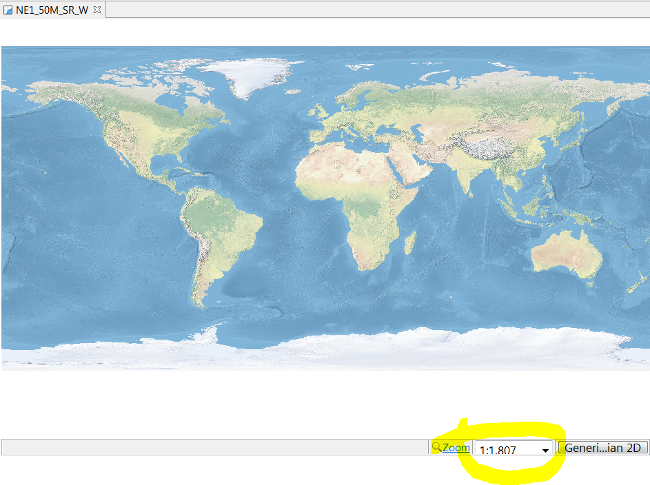
It shows a value that 1000x smaller than expected, maybe its a language/formating issue ina German envorinment
see https://user-images.githubusercontent.com/644229/38777203-6489ab24-40a4-11e8-925f-673dfaf262db.png
In addition for WGS84 in overview, the scale element within the map shows 8m which is also wrong
When editing a shapefile layer, uncommitted features are affected by (almost) all edit operations.
Examples:
Select any feature (e.g. polygon) in a shape file layer. That polygon plus all uncommitted polygons will be selected.
Attempt to delete any feature in a shapefile layer. That polygon plus all uncommitted polygons will be deleted.
Attempt to move/modify the geometry of any feature. All uncommitted features will be assigned a copy of the same geometry. The result is multiple features stacked on top of each other.
This seems to be caused by GeoTools not propagating the filter/query to the DiffFeatureReader. All features in the current transaction will be added to the returned iterator.
ContentFeatureSource.java
To reproduce:
The issue is probably caused by this commit on GeoTools.
geotools/geotools@eb2c9d7
While adding a layer to the map a IllegalStateException is thrown running the SetLayerName Interceptor.
Stacktrace:
!ENTRY org.locationtech.udig.project 1 0 2017-08-23 13:24:18.527
!MESSAGE Error running interceptor: SetLayerName
!STACK 0
java.lang.IllegalStateException: Lookup of getInfo not available from the display thread
	at org.locationtech.udig.catalog.IGeoResource.getInfo(IGeoResource.java:217)
	at org.locationtech.udig.project.internal.impl.SetLayerNameInterceptor.run(SetLayerNameInterceptor.java:29)
	at org.locationtech.udig.project.internal.impl.LayerFactoryImpl.runLayerCreatedInterceptor(LayerFactoryImpl.java:430)
	at org.locationtech.udig.project.internal.impl.LayerFactoryImpl.createLayer(LayerFactoryImpl.java:409)
	at org.locationtech.udig.printing.model.impl.MapGraphicBoxPrinter.setMapGraphic(MapGraphicBoxPrinter.java:292)
	at org.locationtech.udig.printing.model.impl.MapGraphicBoxPrinter.load(MapGraphicBoxPrinter.java:244)
	at org.locationtech.udig.printing.model.impl.ModelFactoryImpl.createBoxPrinterFromString(ModelFactoryImpl.java:298)
	at org.locationtech.udig.printing.model.impl.ModelFactoryImpl.createFromString(ModelFactoryImpl.java:103)
	at org.eclipse.emf.ecore.xmi.impl.XMLHelperImpl.createFromString(XMLHelperImpl.java:1615)
	at org.eclipse.emf.ecore.xmi.impl.XMLHelperImpl.setValue(XMLHelperImpl.java:1156)
	at org.eclipse.emf.ecore.xmi.impl.XMLHandler.setFeatureValue(XMLHandler.java:2692)
	at org.eclipse.emf.ecore.xmi.impl.XMLHandler.setAttribValue(XMLHandler.java:2751)
	at org.eclipse.emf.ecore.xmi.impl.SAXXMIHandler.handleObjectAttribs(SAXXMIHandler.java:79)
	at org.eclipse.emf.ecore.xmi.impl.XMLHandler.createObjectFromFactory(XMLHandler.java:2229)
	at org.eclipse.emf.ecore.xmi.impl.XMLHandler.createObjectFromFeatureType(XMLHandler.java:2195)
	at org.eclipse.emf.ecore.xmi.impl.XMLHandler.createObject(XMLHandler.java:2071)
	at org.eclipse.emf.ecore.xmi.impl.XMIHandler.createObject(XMIHandler.java:128)
	at org.eclipse.emf.ecore.xmi.impl.XMLHandler.handleFeature(XMLHandler.java:1876)
	at org.eclipse.emf.ecore.xmi.impl.XMLHandler.processElement(XMLHandler.java:1030)
	at org.eclipse.emf.ecore.xmi.impl.XMIHandler.processElement(XMIHandler.java:81)
	at org.eclipse.emf.ecore.xmi.impl.XMLHandler.startElement(XMLHandler.java:1008)
	at org.eclipse.emf.ecore.xmi.impl.XMLHandler.startElement(XMLHandler.java:719)
	at org.eclipse.emf.ecore.xmi.impl.XMIHandler.startElement(XMIHandler.java:163)
	at com.sun.org.apache.xerces.internal.parsers.AbstractSAXParser.startElement(AbstractSAXParser.java:509)
	at com.sun.org.apache.xerces.internal.parsers.AbstractXMLDocumentParser.emptyElement(AbstractXMLDocumentParser.java:182)
	at com.sun.org.apache.xerces.internal.impl.XMLDocumentFragmentScannerImpl.scanStartElement(XMLDocumentFragmentScannerImpl.java:1342)
	at com.sun.org.apache.xerces.internal.impl.XMLDocumentFragmentScannerImpl$FragmentContentDriver.next(XMLDocumentFragmentScannerImpl.java:2770)
	at com.sun.org.apache.xerces.internal.impl.XMLDocumentScannerImpl.next(XMLDocumentScannerImpl.java:606)
	at com.sun.org.apache.xerces.internal.impl.XMLDocumentFragmentScannerImpl.scanDocument(XMLDocumentFragmentScannerImpl.java:510)
	at com.sun.org.apache.xerces.internal.parsers.XML11Configuration.parse(XML11Configuration.java:848)
	at com.sun.org.apache.xerces.internal.parsers.XML11Configuration.parse(XML11Configuration.java:777)
	at com.sun.org.apache.xerces.internal.parsers.XMLParser.parse(XMLParser.java:141)
	at com.sun.org.apache.xerces.internal.parsers.AbstractSAXParser.parse(AbstractSAXParser.java:1213)
	at com.sun.org.apache.xerces.internal.jaxp.SAXParserImpl$JAXPSAXParser.parse(SAXParserImpl.java:649)
	at com.sun.org.apache.xerces.internal.jaxp.SAXParserImpl.parse(SAXParserImpl.java:333)
	at org.eclipse.emf.ecore.xmi.impl.XMLLoadImpl.load(XMLLoadImpl.java:175)
	at org.eclipse.emf.ecore.xmi.impl.XMLResourceImpl.doLoad(XMLResourceImpl.java:261)
	at org.eclipse.emf.ecore.resource.impl.ResourceImpl.load(ResourceImpl.java:1518)
	at org.eclipse.emf.ecore.resource.impl.ResourceImpl.load(ResourceImpl.java:1297)
	at org.eclipse.emf.ecore.resource.impl.ResourceSetImpl.demandLoad(ResourceSetImpl.java:259)
	at org.eclipse.emf.ecore.resource.impl.ResourceSetImpl.demandLoadHelper(ResourceSetImpl.java:274)
	at org.eclipse.emf.ecore.resource.impl.ResourceSetImpl.getResource(ResourceSetImpl.java:377)
	at org.eclipse.emf.ecore.resource.impl.ResourceSetImpl.getEObject(ResourceSetImpl.java:220)
	at org.eclipse.emf.ecore.util.EcoreUtil.resolve(EcoreUtil.java:199)
	at org.eclipse.emf.ecore.util.EcoreUtil.resolve(EcoreUtil.java:259)
	at org.eclipse.emf.ecore.impl.BasicEObjectImpl.eResolveProxy(BasicEObjectImpl.java:1473)
	at org.eclipse.emf.ecore.util.EcoreEList.resolveProxy(EcoreEList.java:206)
	at org.eclipse.emf.ecore.util.EcoreEList.resolve(EcoreEList.java:161)
	at org.eclipse.emf.ecore.util.EObjectWithInverseResolvingEList.resolve(EObjectWithInverseResolvingEList.java:93)
	at org.eclipse.emf.common.util.BasicEList.get(BasicEList.java:348)
	at org.locationtech.udig.project.internal.impl.SynchronizedEObjectWithInverseResolvingEList.get(SynchronizedEObjectWithInverseResolvingEList.java:75)
	at org.eclipse.emf.ecore.util.EcoreEList.toArray(EcoreEList.java:216)
	at java.util.Collections$UnmodifiableCollection.toArray(Collections.java:1058)
	at java.util.ArrayList.<init>(ArrayList.java:164)
	at org.locationtech.udig.project.internal.provider.ProjectItemProvider.getConcreteChildren(ProjectItemProvider.java:175)
	at org.locationtech.udig.project.internal.provider.AbstractLazyLoadingItemProvider.getChildren(AbstractLazyLoadingItemProvider.java:103)
	at org.eclipse.emf.edit.ui.provider.AdapterFactoryContentProvider.getChildren(AdapterFactoryContentProvider.java:175)
	at org.locationtech.udig.project.ui.internal.UDIGAdapterFactoryContentProvider.getChildren(UDIGAdapterFactoryContentProvider.java:67)
	at org.eclipse.jface.viewers.AbstractTreeViewer.getRawChildren(AbstractTreeViewer.java:1372)
	at org.eclipse.jface.viewers.TreeViewer.getRawChildren(TreeViewer.java:353)
	at org.eclipse.jface.viewers.StructuredViewer.getFilteredChildren(StructuredViewer.java:905)
	at org.eclipse.jface.viewers.AbstractTreeViewer.getSortedChildren(AbstractTreeViewer.java:617)
	at org.eclipse.jface.viewers.AbstractTreeViewer.updateChildren(AbstractTreeViewer.java:2649)
	at org.eclipse.jface.viewers.AbstractTreeViewer.internalRefreshStruct(AbstractTreeViewer.java:1918)
	at org.eclipse.jface.viewers.TreeViewer.internalRefreshStruct(TreeViewer.java:684)
	at org.eclipse.jface.viewers.AbstractTreeViewer.internalRefresh(AbstractTreeViewer.java:1893)
	at org.eclipse.jface.viewers.AbstractTreeViewer.internalRefresh(AbstractTreeViewer.java:1850)
	at org.eclipse.jface.viewers.StructuredViewer$8.run(StructuredViewer.java:1528)
	at org.eclipse.jface.viewers.StructuredViewer.preservingSelection(StructuredViewer.java:1436)
	at org.eclipse.jface.viewers.TreeViewer.preservingSelection(TreeViewer.java:366)
	at org.eclipse.jface.viewers.StructuredViewer.preservingSelection(StructuredViewer.java:1397)
	at org.eclipse.jface.viewers.StructuredViewer.refresh(StructuredViewer.java:1525)
	at org.eclipse.jface.viewers.ColumnViewer.refresh(ColumnViewer.java:533)
	at org.eclipse.emf.edit.ui.provider.AdapterFactoryContentProvider$ViewerRefresh.refresh(AdapterFactoryContentProvider.java:495)
	at org.eclipse.emf.edit.ui.provider.AdapterFactoryContentProvider$ViewerRefresh.run(AdapterFactoryContentProvider.java:459)
	at org.eclipse.swt.widgets.RunnableLock.run(RunnableLock.java:35)
	at org.eclipse.swt.widgets.Synchronizer.runAsyncMessages(Synchronizer.java:136)
	at org.eclipse.swt.widgets.Display.runAsyncMessages(Display.java:4147)
	at org.eclipse.swt.widgets.Display.readAndDispatch(Display.java:3764)
	at org.eclipse.e4.ui.internal.workbench.swt.PartRenderingEngine$9.run(PartRenderingEngine.java:1151)
	at org.eclipse.core.databinding.observable.Realm.runWithDefault(Realm.java:332)
	at org.eclipse.e4.ui.internal.workbench.swt.PartRenderingEngine.run(PartRenderingEngine.java:1032)
	at org.eclipse.e4.ui.internal.workbench.E4Workbench.createAndRunUI(E4Workbench.java:148)
	at org.eclipse.ui.internal.Workbench$5.run(Workbench.java:636)
	at org.eclipse.core.databinding.observable.Realm.runWithDefault(Realm.java:332)
	at org.eclipse.ui.internal.Workbench.createAndRunWorkbench(Workbench.java:579)
	at org.eclipse.ui.PlatformUI.createAndRunWorkbench(PlatformUI.java:150)
	at org.locationtech.udig.internal.ui.UDIGApplication.start(UDIGApplication.java:132)
	at org.eclipse.equinox.internal.app.EclipseAppHandle.run(EclipseAppHandle.java:196)
	at org.eclipse.core.runtime.internal.adaptor.EclipseAppLauncher.runApplication(EclipseAppLauncher.java:134)
	at org.eclipse.core.runtime.internal.adaptor.EclipseAppLauncher.start(EclipseAppLauncher.java:104)
	at org.eclipse.core.runtime.adaptor.EclipseStarter.run(EclipseStarter.java:380)
	at org.eclipse.core.runtime.adaptor.EclipseStarter.run(EclipseStarter.java:235)
	at sun.reflect.NativeMethodAccessorImpl.invoke0(Native Method)
	at sun.reflect.NativeMethodAccessorImpl.invoke(NativeMethodAccessorImpl.java:57)
	at sun.reflect.DelegatingMethodAccessorImpl.invoke(DelegatingMethodAccessorImpl.java:43)
	at java.lang.reflect.Method.invoke(Method.java:606)
	at org.eclipse.equinox.launcher.Main.invokeFramework(Main.java:648)
	at org.eclipse.equinox.launcher.Main.basicRun(Main.java:603)
	at org.eclipse.equinox.launcher.Main.run(Main.java:1465)
	at org.eclipse.equinox.launcher.Main.main(Main.java:1438)
Currently 19.4 is bundled in uDig and GeoTools supports Java 11 beginning with version 21.0
This issue is about to upgrade to GeoTools 21++ independently from Java-Version.
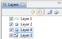
Dependent from the current selection in LayersView it sometimes doesn't make sense to allow move up/move down of the currently selected layers. For example, if the layer is on top of all others the move up action should be disabled.

This fix is related to #240
see MapEditorWithPalette.ID and MapEditor.ID.
org.locationtech.udig.project.ui.internal.MapEditor.ID is "org.locationtech.udig.project.ui.mapEditor" and doesn' match the id used in Extension-point
<extension
         point="org.eclipse.ui.editors">
      <editor
            class="org.locationtech.udig.project.ui.internal.MapEditor"
            contributorClass="org.locationtech.udig.project.ui.internal.MapEditorActionBarContributor"
            default="false"
            icon="icons/obj16/map_obj.gif"
            id="org.locationtech.udig.project.ui.mapEditorOld"
            name="%mapEditor.name">
      </editor>
org.locationtech.udig.project.ui.internal.MapEditorWithPalette.ID has the same value which matches the id in extension point (project.edit plugin):
Question: How can I configure uDig to use "old" Editor without Palette for Actions? How is EditorInput associated with MapEditor?
To reproduce:
(A related problem is that a triangular polygon drawn with CCW winding will not be converted to CW. You'll need a debugger to observe this.)
To reproduce:
I believe this is caused by a bug in GeoTools.
GEOT-6275
PostGIS layers with type "Geometry" seem to work correctly.
.. sometimes so its kind of flaky:
WFSGeoResourceTest.testCanResolve » TestTimedOut test timed out after 150 mill...
if you select more than one layer in the Layers View and use the arrow button "Move the selected layers down" the movement is only between the selected layers and not all the selected down.
Original reported by Silvia Franceschi and reported as UDIG-1962
To reproduce:
Then nothing happens and a NullPointerException is logged for OpenStyleEditorAction in background:
!ENTRY org.eclipse.ui 4 0 2018-05-03 10:13:22.589
!MESSAGE Unhandled event loop exception
!STACK 0
java.lang.NullPointerException
	at org.locationtech.udig.style.sld.editor.OpenStyleEditorAction.run(OpenStyleEditorAction.java:112)
	at org.eclipse.ui.internal.PluginAction.runWithEvent(PluginAction.java:247)
	at org.eclipse.jface.action.ActionContributionItem.handleWidgetSelection(ActionContributionItem.java:565)
	at org.eclipse.jface.action.ActionContributionItem.lambda$5(ActionContributionItem.java:436)
	at org.eclipse.swt.widgets.EventTable.sendEvent(EventTable.java:86)
	at org.eclipse.swt.widgets.Display.sendEvent(Display.java:4428)
	at org.eclipse.swt.widgets.Widget.sendEvent(Widget.java:1079)
	at org.eclipse.swt.widgets.Display.runDeferredEvents(Display.java:4238)
	at org.eclipse.swt.widgets.Display.readAndDispatch(Display.java:3817)
	at org.eclipse.e4.ui.internal.workbench.swt.PartRenderingEngine$5.run(PartRenderingEngine.java:1150)
	at org.eclipse.core.databinding.observable.Realm.runWithDefault(Realm.java:336)
	at org.eclipse.e4.ui.internal.workbench.swt.PartRenderingEngine.run(PartRenderingEngine.java:1039)
	at org.eclipse.e4.ui.internal.workbench.E4Workbench.createAndRunUI(E4Workbench.java:153)
	at org.eclipse.ui.internal.Workbench.lambda$3(Workbench.java:680)
	at org.eclipse.core.databinding.observable.Realm.runWithDefault(Realm.java:336)
	at org.eclipse.ui.internal.Workbench.createAndRunWorkbench(Workbench.java:594)
	at org.eclipse.ui.PlatformUI.createAndRunWorkbench(PlatformUI.java:148)
	at org.locationtech.udig.internal.ui.UDIGApplication.start(UDIGApplication.java:132)
	at org.eclipse.equinox.internal.app.EclipseAppHandle.run(EclipseAppHandle.java:196)
	at org.eclipse.core.runtime.internal.adaptor.EclipseAppLauncher.runApplication(EclipseAppLauncher.java:134)
	at org.eclipse.core.runtime.internal.adaptor.EclipseAppLauncher.start(EclipseAppLauncher.java:104)
	at org.eclipse.core.runtime.adaptor.EclipseStarter.run(EclipseStarter.java:388)
	at org.eclipse.core.runtime.adaptor.EclipseStarter.run(EclipseStarter.java:243)
	at sun.reflect.NativeMethodAccessorImpl.invoke0(Native Method)
	at sun.reflect.NativeMethodAccessorImpl.invoke(Unknown Source)
	at sun.reflect.DelegatingMethodAccessorImpl.invoke(Unknown Source)
	at java.lang.reflect.Method.invoke(Unknown Source)
	at org.eclipse.equinox.launcher.Main.invokeFramework(Main.java:653)
	at org.eclipse.equinox.launcher.Main.basicRun(Main.java:590)
	at org.eclipse.equinox.launcher.Main.run(Main.java:1499)
	at org.eclipse.equinox.launcher.Main.main(Main.java:1472)
Hi,
It seems there is a serious problem when someone attempts to copy from a shapefile layer a feature and paste it to the same layer. A subsequent commit never completes and seems to blocks indefinitely the UI.
This issue was not present in old udig 1.4 (geotools 9.0-M0 and seems to have occured after shifting to locationtech and newer version of geotools (geotools 14.1).
How to reproduce:
Implementation in InitMapCRS has wrong behavior. If a product is configured using e.g. Pseudo-Mercator with:
org.locationtech.udig.project/defaultCRSPreference=3857
the first added layer changes ViewportModel CRS to its given (different) CRS (e.g. EPSG:4326)
Expected behavior: Whenever a different default is configured and EPSG code is fine, the ViewportModel CRS should be unchanged whenever a layer is added to the map.
see second part of if-statement:
what can i do??? i just run it.

By using a LayerInterceptor extension to detect added layers and inside the callback for an added layer I set the visibility of some added layers to false. This sometimes causes this excpetion:
Caused by: java.util.ConcurrentModificationException
                at org.eclipse.emf.common.util.AbstractEList$EIterator.checkModCount(AbstractEList.java:762)
                at org.eclipse.emf.common.util.AbstractEList$EIterator.doNext(AbstractEList.java:710)
                at org.eclipse.emf.common.util.AbstractEList$EIterator.next(AbstractEList.java:696)
                at org.locationtech.udig.project.ui.internal.LayersView.requiresCheckboxUpdate(LayersView.java:511)
                at org.locationtech.udig.project.ui.internal.LayersView.access$1(LayersView.java:585)
                at org.locationtech.udig.project.ui.internal.LayersView$7.run(LayersView.java:561)
@silviafranceschi reported an issue (uDig/udig-extras#1) :
I am trying to run uDig 2.0.0.RC1 on MacOS with operating system Catalina and java JRE Java8: 1.8.0_241.
I can install it but when I start it all seems to work but nothing can be done from the GUI, all freezes and I have to exit from the icon of the application in the docker.
.. to allow SDK-Users to choose the prefered selection tools. Right now Integrators can only use the selection bundle which contributes different types of selection tools (Arrow, Rectangle and Area of Interest - AOI).
From my perspective its quite hard to remove one of this tools from own RCP-Application (transformations before plug-in registry is filled).
It would be great to have different bundles for at least AOI and standard selection tools. In addition to #217 it would be a plus to seperate standard selection tools as well (ArrowSelection vs. ArrowSelectionWithPopup).
to fix open tasks for CQ 7142
Update to geotools 19.x which implies JTS upgrade to 1.14.0 two test failing:
For now we skip these to resolve the problem with this issue
It seems that if a feature layer is set as not visible then (if selected in the LayerView) tool actions like select, delete, edit etc are still possible for its features.
I wonder whether this is a desired behavior or it should be prohibited. Opinions?
Moved this PR into in-progress state, since I need to fix comments and probably to add the old version / function that will allow to get resolutions by the GDALDataset.TYPE
Originally posted by @pomadchin in locationtech/geotrellis#3125
within the help-bundle uDig help (made for version 1.1.1) is included which is a bit outdated. To avoid confusions the help should be removed (was user-Doc from codehouse wiki)
Miss it since udig upgraded zu Eclipse E4 Platform.
This is open for discussion to remove support for Windows 32bit and Linux 32bit platforms as we did for MacOSX (due to upgrade to newer Eclipse Release)
This would help to speed up the build and reduce required discspace in both, target folders and .m2 repositories.
Please let us know your point of view
Hi,
I'd like to connect H2GIS (https://github.com/orbisgis/h2gis-geotools) with the UDIG (2.0.0).
I'm not able to find a documentation about that.
Could you please point me some resources...
Thanks
Ps : I tried to make a maven project based on the Postgis plugin but I can't compile it. I use the NetBeans IDE.
The following WMS do not work correctly in uDig:
http://www.gds-srv.hessen.de/cgi-bin/lika-services/ogc-free-maps.ows
Only the top-layer is rendered. If i add the sub-layers seperatly they don't get rendered. In other GIS Tools this is working correct.
http://www.gds-srv.hessen.de/cgi-bin/lika-services/ogc-free-images.ows
Doesn't get rendered at all.
Original report : UDIG-2061
Currently 0.22.0 is used to build uDig RCP application. Many new features were implementen since (see release Tycho notes) which might help
the current latest version of udig uses luna target environment but suffers from a number of limitations/performance issues like:
upgrading to eclipse neon target environment may resolve this UI issues and improve performance
Right now the help bundle has required-bundle dependency to org.eclipse.ui.cheatsheets.
For uDig itself its uncritical but for RCP-Apps build on top or with uDig containing help, it should be an option to have cheatsheets.
In addition, there is an unused dependency to org.eclipse.ui.intro from help-bundle, please remove it too
This allows an integrator to choose if cheatsheets should be a part of a product or not.
affected bundles:
expectation:
new bundles with cheatsheet content and extensions (e.g. org.locationtech.udig.project.ui.cheats for project related cheatsheets)
When using udig (Version: 2.0.0), and trying to do a WMS GetFeatureInfo request, I get the following error:
<ServiceExceptionReport xmlns="http://www.opengis.net/ogc" xmlns:xsi="http://www.w3.org/2001/XMLSchema-instance" version="1.3.0" xsi:schemaLocation="http://www.opengis.net/ogc http://schemas.opengis.net/wms/1.3.0/exceptions_1_3_0.xsd">
<ServiceException code="MissingParameterValue">
msWMSLoadGetMapParams(): WMS server error. Missing required parameter CRS
</ServiceException>
</ServiceExceptionReport>
as per below screen shot

The actual request sent is (xxx.xxx.xxx substituting for server name):
Adding &CRS=EPSG:4326& to the end AND switching the BBOX axes to BBOX=0.03824996332654984,30.889154617208934,1.820055916855415,33.29548059763911& gives the expected response
Upgrade to latest stable GeoTools release and update Required execution Environment to Java 1.8
Required Execution Enviroment discussed in #256
On Windows 10 the viewport is rendered at the native resolution of the display. On high DPI displays frame-rates can decay quickly with the size of the viewport.
e.g. on a laptop with a 1440p display and an i7-7500U the geometry creation tools can be very laggy. I suspect things will be much worse on a 4K laptop. Maybe someone has tried?
og4j:WARN No appenders could be found for logger (org.geotools.factory).
log4j:WARN Please initialize the log4j system properly.
This is part of a general problem of a number of warning messages being issued as various open source projects start up.
The following clarification was offered on the user list
Hi Donovan,
This is related to the way that log4j uses reflection to find the appender.
I haven't looked deeply within the new udig 1.3.0 code base yet so I am not sure where things have moved and indeed if there is a log appender, but I did notice that there is a bundled org.apache.log4 library.
I have been running with SLF and log4j logging in my RCP plugins for some time and there are a couple of things that need to be done to permit log4j to work from plugins, please view the notes below:
Manifest-Version: 1.0
Bundle-ManifestVersion: 2
Bundle-Name: org.apache.log4j
Bundle-SymbolicName: org.apache.log4j
Bundle-Version: 9.0.1.20110423
Bundle-Vendor: Apache Log4j
Export-Package: org.apache.log4j,
org.apache.log4j.chainsaw,
org.apache.log4j.config,
org.apache.log4j.helpers,
org.apache.log4j.jdbc,
org.apache.log4j.jmx,
org.apache.log4j.lf5,
org.apache.log4j.lf5.config,
org.apache.log4j.lf5.util,
org.apache.log4j.lf5.viewer,
org.apache.log4j.lf5.viewer.categoryexplorer,
org.apache.log4j.lf5.viewer.configure,
org.apache.log4j.lf5.viewer.images,
org.apache.log4j.net,
org.apache.log4j.nt,
org.apache.log4j.or,
org.apache.log4j.or.jms,
org.apache.log4j.or.sax,
org.apache.log4j.spi,
org.apache.log4j.varia,
org.apache.log4j.xml
Eclipse-BuddyPolicy: registered
Bundle-RequiredExecutionEnvironment: JavaSE-1.6
/*******************************************************************************
Copyright (c) 2005 John J. Franey
All rights reserved. This program and the accompanying materials
are made available under the terms of the Eclipse Public License v1.0
which accompanies distribution, and is available at
http://www.eclipse.org/legal/epl-v10.html
*
*******************************************************************************/
IR_GIS;
java.text.MessageFormat;
org.apache.log4j.AppenderSkeleton;
org.apache.log4j.Level;
org.apache.log4j.spi.LoggingEvent;
org.eclipse.core.runtime.ILog;
org.eclipse.core.runtime.IStatus;
org.eclipse.core.runtime.Platform;
org.eclipse.core.runtime.Status;
org.osgi.framework.Bundle;
/**
log4j appender to an eclipse plugin's Ilog.
@author John J. Franey
*
*/
AppenderSkeleton
{
symbolicName;
/* (non-Javadoc)
@see org.apache.log4j.AppenderSkeleton#append(org.apache.log4j.spi.LoggingEvent)
*/
void append(LoggingEvent event)
Unknown macro: { event is not severe enough. ; ILog log = getBundleILog(); ; throwable information is available, extract it. Throwable t = ; && layout.ignoresThrowable()) t = event.getThrowableInformation().getThrowable(); // build an Eclipse Status record, map severity and code from Event. Status s = Status(getSeverity(event), getSymbolicName(), getCode(event), layout.format(event), t); log.log(s); }
/**
map LoggingEvent's level to Status severity
@param ev
@
*/
getSeverity(LoggingEvent ev)
Unknown macro: { Level level = ev.getLevel(); (level == Level.FATAL || level == Level.ERROR) IStatus.ERROR; (level == Level.WARN) IStatus.WARNING; (level == Level.INFO) IStatus.INFO; // debug, trace and custom levels IStatus.OK; }
/**
Return the pluginId under which the messages will be logged
@
*/
getSymbolicName()
Unknown macro: { .symbolicName; }
name)
Unknown macro: { .symbolicName = name; }
/**
map LoggingEvent to Status code
@param ev
@
*/
getCode(LoggingEvent ev)
Unknown macro: { 0; }
ILog getBundleILog() {
a plug-in
Bundle b = Platform.getBundle(getSymbolicName());
)
Unknown macro: { //$NON-NLS-1$ .name}
);
.errorHandler.error(m);
;
}
Platform.getLog(b);
}
void close()
Unknown macro: { // nothing to close }
requiresLayout()
Unknown macro: { ; }
}
Then you need to make that PluginLogAppender visible by reflection, using an: Eclipse-RegisterBuddy: org.apache.log4j directive within the plugin manifest e.g.:
Manifest-Version: 1.0
Bundle-ManifestVersion: 2
Bundle-Name: IR_GIS (TM) Innovative Real-time Geographic Information
Bundle-SymbolicName: IR_GIS;singleton:=
Bundle-Version: 1.2.18
Bundle-Activator: IR_GIS.IRGISPlugin
Bundle-Vendor: Arising Technology Systems Pty Limited
Require-Bundle: org.apache.log4j,
ri.common,
net.refractions.udig.project,
net.refractions.udig.mapgraphic,
net.refractions.udig.printing.model,
net.refractions.udig.printing.ui,
net.refractions.udig.tool.,
net.refractions.udig.tool.info,
net.refractions.udig.ui,
ri.checklogin;bundle-version=;resolution:=optional,
ri.udig.InfotoolOverride;bundle-version=;resolution:=optional
Import-Package: org.eclipse.ui.plugin,
org.slf4j
Eclipse-RegisterBuddy: org.apache.log4j
Bundle-RequiredExecutionEnvironment: JavaSE-1.6
Bundle-ActivationPolicy: lazy
Export-Package: IR_GIS;version=
// Obtain the properties file to start the appender
IConfiguration config = ConfigurationFactory.getDefault();
//$NON-NLS-1$
, pathName));
PropertyConfigurator.configure(pathName);
logger = LoggerFactory.getLogger(.getClass());
(Note that ConfigurationFactory is proprietary code, you will need to use some other means to obtain the pathname to the log4k.properties file.)
I haven't spent any time using more than one plugin to contain the PluginLogAppender, nor tried to investigate whether the 1.3.0 udig code base actually contains one or more PluginLogAppender instances or equivalent classes, but my product has been running with one appender setup this way for over a year, perhaps this is something the development team can fix in the current udig code base?
Ralph Holland
The following CRS (on uDig projections database) do not have the necessary TOWGS84 parameters:
This cause a displacement of 200-300 meters in Portugal mainland.
It is also necessary to provide the equivalence between the following ESRI projections:
Please refer to: http://epsg.io/
Warning: DO NOT use http://spatialreference.org
Please find attached samples of Portuguese projections.
Regards
Antonio
2.0.0 fails on startup with "An error has occured" popup directing you to a logfile (below)
MacOS Mojave 10.14
$ java -version
java version "11" 2018-09-25
Java(TM) SE Runtime Environment 18.9 (build 11+28)
Java HotSpot(TM) 64-Bit Server VM 18.9 (build 11+28, mixed mode)
$ cat 1539004925670.log
!SESSION 2018-10-08 08:22:05.475 -----------------------------------------------
eclipse.buildId=unknown
java.version=11
java.vendor=Oracle Corporation
BootLoader constants: OS=macosx, ARCH=x86_64, WS=cocoa, NL=en_US
Framework arguments:  -keyring /Users/user/.eclipse_keyring
Command-line arguments:  -os macosx -ws cocoa -arch x86_64 -keyring /Users/user/.eclipse_keyring

!ENTRY org.eclipse.osgi 4 0 2018-10-08 08:22:07.622
!MESSAGE Application error
!STACK 1
java.lang.ExceptionInInitializerError
        at org.locationtech.udig.libs.internal.Activator.doEpsg(Activator.java:274)
        at org.locationtech.udig.libs.internal.Activator.epsgDatabaseFile(Activator.java:259)
        at org.locationtech.udig.internal.ui.UDIGApplication.init(UDIGApplication.java:168)
        at org.locationtech.udig.internal.ui.UDIGApplication.start(UDIGApplication.java:126)
        at org.eclipse.equinox.internal.app.EclipseAppHandle.run(EclipseAppHandle.java:196)
        at org.eclipse.core.runtime.internal.adaptor.EclipseAppLauncher.runApplication(EclipseAppLauncher.java:134)
        at org.eclipse.core.runtime.internal.adaptor.EclipseAppLauncher.start(EclipseAppLauncher.java:104)
        at org.eclipse.core.runtime.adaptor.EclipseStarter.run(EclipseStarter.java:388)
        at org.eclipse.core.runtime.adaptor.EclipseStarter.run(EclipseStarter.java:243)
        at java.base/jdk.internal.reflect.NativeMethodAccessorImpl.invoke0(Native Method)
        at java.base/jdk.internal.reflect.NativeMethodAccessorImpl.invoke(NativeMethodAccessorImpl.java:62)
        at java.base/jdk.internal.reflect.DelegatingMethodAccessorImpl.invoke(DelegatingMethodAccessorImpl.java:43)
        at java.base/java.lang.reflect.Method.invoke(Method.java:566)
        at org.eclipse.equinox.launcher.Main.invokeFramework(Main.java:653)
        at org.eclipse.equinox.launcher.Main.basicRun(Main.java:590)
        at org.eclipse.equinox.launcher.Main.run(Main.java:1499)
Caused by: java.lang.IllegalArgumentException: org.geotools.styling.StyleFactory is not an ImageIO SPI class
        at java.desktop/javax.imageio.spi.ServiceRegistry.checkClassAllowed(ServiceRegistry.java:722)
        at java.desktop/javax.imageio.spi.ServiceRegistry.<init>(ServiceRegistry.java:117)
        at org.geotools.factory.FactoryRegistry.<init>(FactoryRegistry.java:155)
        at org.geotools.factory.FactoryCreator.<init>(FactoryCreator.java:91)
        at org.geotools.factory.CommonFactoryFinder.getServiceRegistry(CommonFactoryFinder.java:76)
        at org.geotools.factory.CommonFactoryFinder.lookup(CommonFactoryFinder.java:346)
        at org.geotools.factory.CommonFactoryFinder.getFilterFactory(CommonFactoryFinder.java:300)
        at org.geotools.factory.CommonFactoryFinder.getFilterFactory2(CommonFactoryFinder.java:390)
        at org.geotools.factory.CommonFactoryFinder.getFilterFactory2(CommonFactoryFinder.java:404)
        at org.geotools.data.DataUtilities.<clinit>(DataUtilities.java:204)
        ... 16 more
For both platforms, 32bit and 64bit the zip archives for 2.0.0.RC1 provides a _MACOSX folder. Reported issue from OSGeo Live Project see Issue #1953.
When using the create Polygon or Fill Area tools the image background will refresh an old render creating a flicker. It is not a white flicker like a refresh, but rather it loads a new image, then loads an old image, then loads a newer image. This seems to be caused by the EditToolHandler repaint() method. Specifically the edit tools listeners will fire a repaint request to the ViewportPane at the same time as the ViewportPane lifecycle is repainting.
To reproduce:
Hi,
Is it possible to develop standalone applications using udig framework?If yes can you please share me some resources and etc to start with this framework?
If running uDig of a long time with a lots of feature events for different layers, the collection increases constantly of time. There is a clean() call in add(index, object) that clear the cache of amount of features it larger than 10.
Due to implementation of EDataTypeUniqueEList and javadoc givs a hint that it also has significant performance impact
After I installed 2.0,When I run the app,Alert a error :The Udig_internal executable launcher was unable to locate its
companion shared library.
To reproduce:
This seems to have been considerably reduced by the recent rendering performance improvements.
A declarative, efficient, and flexible JavaScript library for building user interfaces.
🖖 Vue.js is a progressive, incrementally-adoptable JavaScript framework for building UI on the web.
TypeScript is a superset of JavaScript that compiles to clean JavaScript output.
An Open Source Machine Learning Framework for Everyone
The Web framework for perfectionists with deadlines.
A PHP framework for web artisans
Bring data to life with SVG, Canvas and HTML. 📊📈🎉
JavaScript (JS) is a lightweight interpreted programming language with first-class functions.
Some thing interesting about web. New door for the world.
A server is a program made to process requests and deliver data to clients.
Machine learning is a way of modeling and interpreting data that allows a piece of software to respond intelligently.
Some thing interesting about visualization, use data art
Some thing interesting about game, make everyone happy.
We are working to build community through open source technology. NB: members must have two-factor auth.
Open source projects and samples from Microsoft.
Google ❤️ Open Source for everyone.
Alibaba Open Source for everyone
Data-Driven Documents codes.
China tencent open source team.