Coder Social home page Coder Social logo

susmeetjain / walkable_mumbai Goto Github PK

View Code? Open in Web Editor NEW

This project forked from gboeing/ppde642

0.0 1.0 1.0 145.78 MB

This is our attempt to understand walkability in Indian cities visually. We have adapted the code developed at Berkeley for the Indian city of Mumbai.

Jupyter Notebook 100.00%

walkable_mumbai's Introduction

An Analysis of Walkability in Mumbai

Introduction

Walkability is the ability of a citizen to walk around to amenities like schools and restaurants without taking a car. Walkability is a very important element in good urban design. It has especially become relevant today in countries like India. Roads in our cities have reached their limits in terms of the volume of traffic they can handle. The only way to inhabit more people into our cities while keeping them livable is to make them more walkable.

Why Mumbai?

The commercial capital of India, Mumbai has seen a massive growth in the recent decades. The subsequent rise in population has led to extremely overcrowded suburban railways and jam packed roads. This has adversely affected the livability of the city and the overall quality of lives of its citizens. It becomes very important in such a scenario to have the ability to bypass these burgeoning modes of transport and simply access day to day amenities by walking to them. In this project, we visualize the walkability in Mumbai for 3 common amenities, restaurants, schools and bars. We believe that accessibility to these amenities is important for families, kids and bachelors in that order, this narrowly covers walkability for major categories of citizens.

Our Findings

Overall Walkability

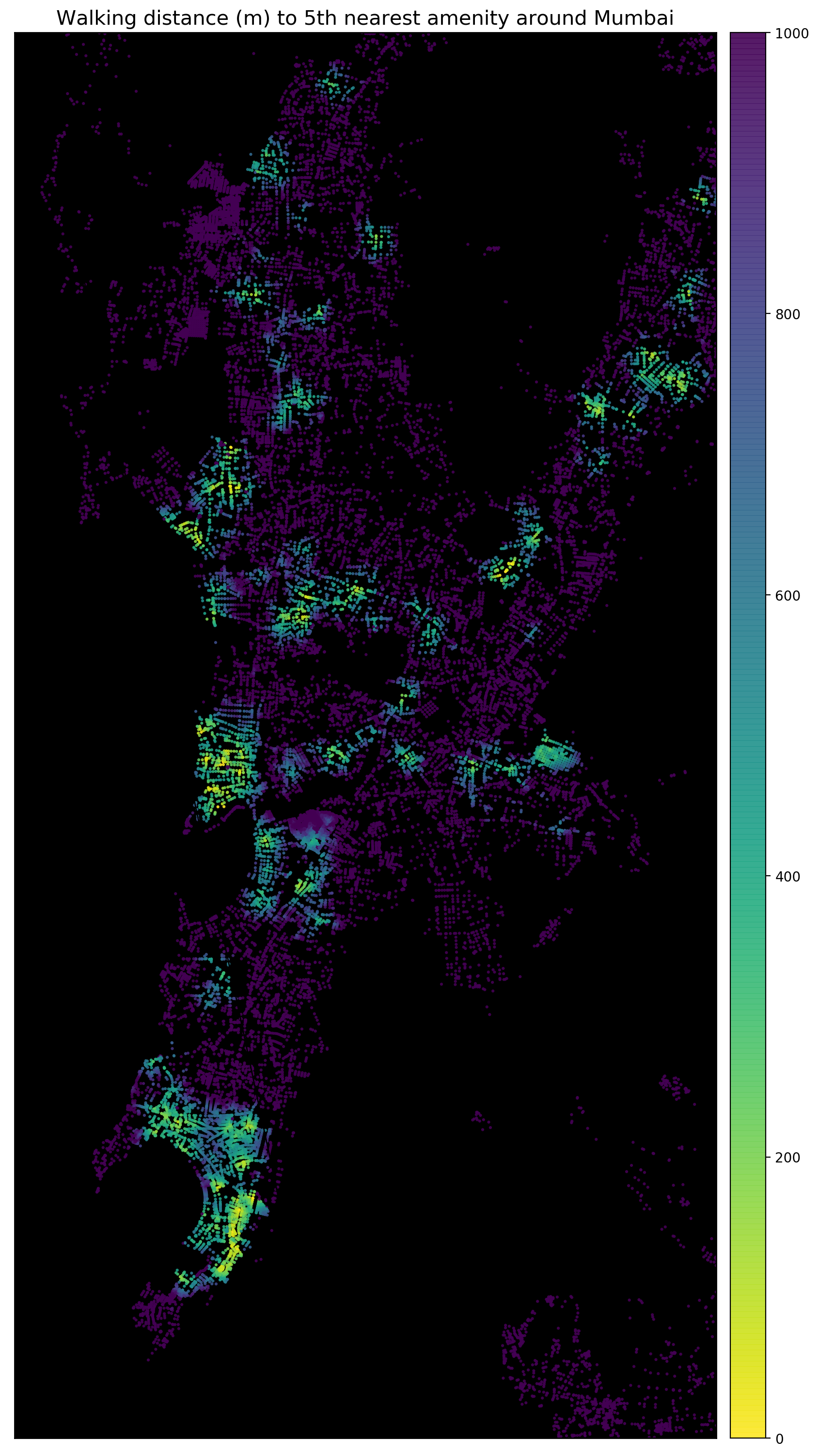
We start by visualizing overall walkability i.e. the combined walkability to all the 3 selected amenities, schools, bars and restaurants.

The first figure on the left visualizes your ability to walk to the nearest amenity. While the second figure on the right represents accessibility to the 5th nearest amenity, which is a more useful visualization, you should have accessibility to more than one amenity to be able to not have a car and just walk around. And clearly such areas are limited. You can see areas that are shining green, this is where you would want to be in Mumbai if you are not fond of long hours spent in traffic jams on roads.

Amenity wise Walkability

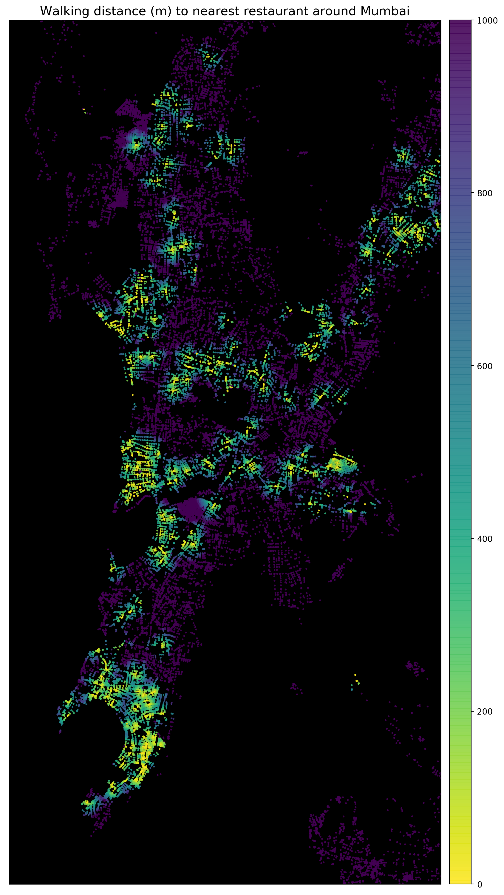
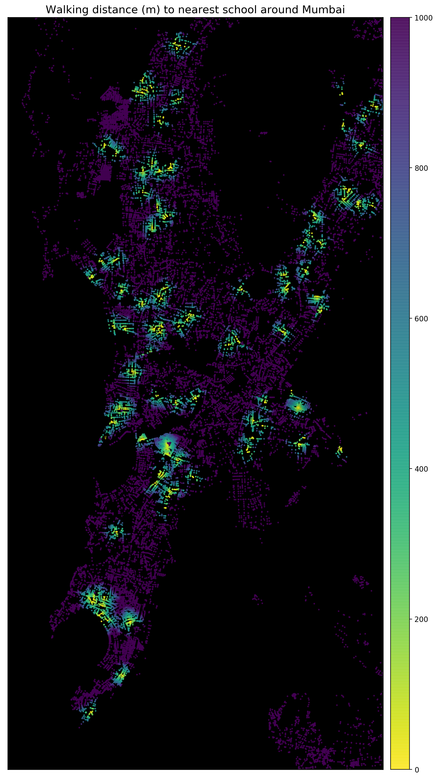
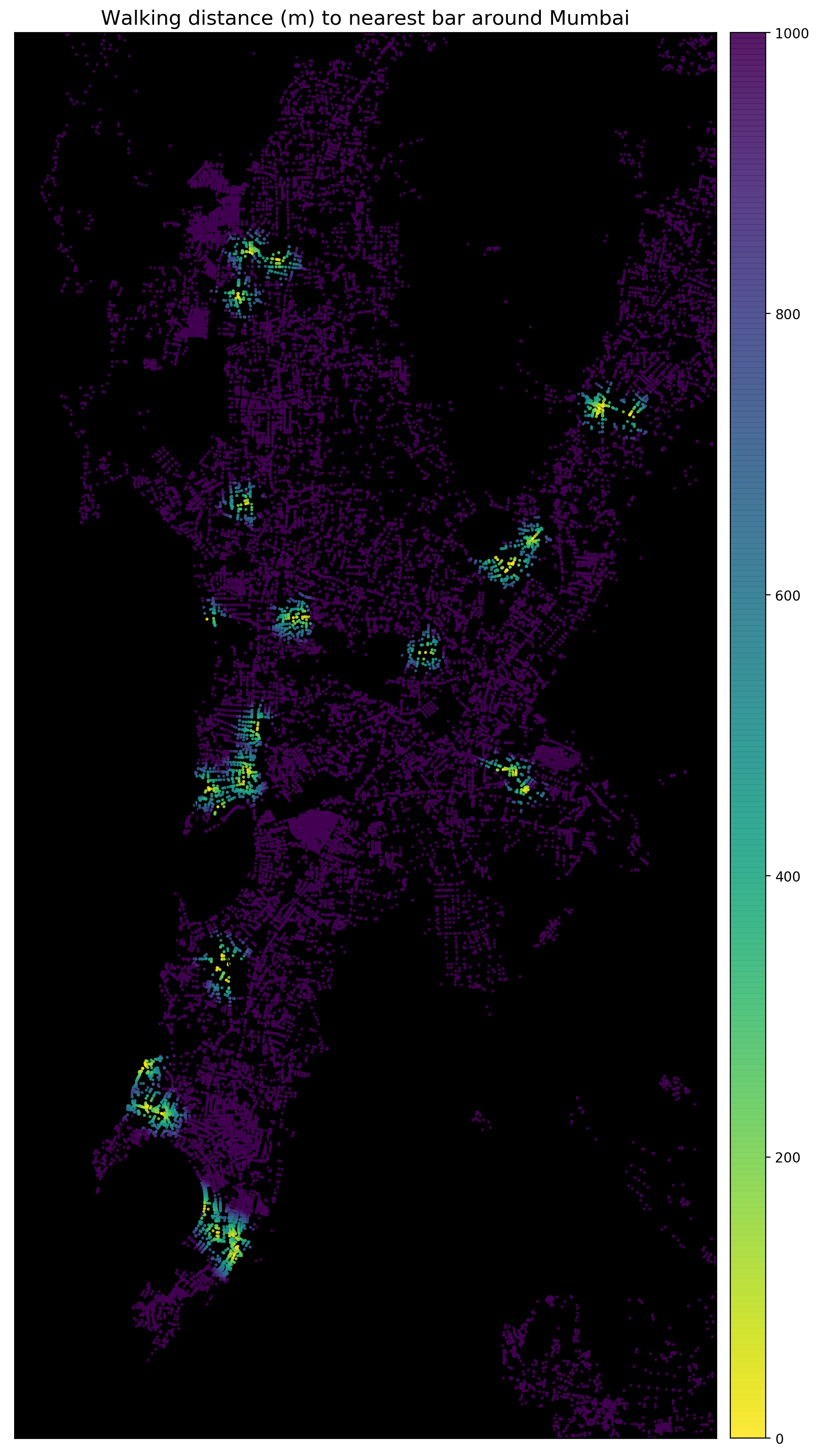
Next we visualize individual accessbility to different amenities.

Mumbai seems to have a fairly decent availability of restaurants around the city. (left) Schools however seem to be available in select few residential areas. (centre) You want to be around the select green areas in the right most figures if you are a party buff.

Data Sources and tools used

This project was originally developed at Berkeley to visualize walkability in the Bay Area. We have adapted their work for Mumbai. Also we have updated the code to use python3 and pandana 0.4 The data for this work is obtained from open street maps. It is an open source, community curated map. We use the pandana library to access this data. Also the pandana library internally uses the osm overpass API.

Running this project

You can clone the entire project or just the jupyter notebook 'Visualizing Walkability in Mumbai.ipynb'. Rest of the files can be generated as you run the code in the notebook.

Conclusion

We talked about the importance of walkability in our introduction section. Through this project, we have tried to make walkability more visual and tangible

We saw clusters of areas that are walkable and others that are not. In a city like Mumbai, we need a lot more walkability than there currently is. We would also like to say that Mumbai is just one city that we picked up. But we see Mumbai as a representation of any major city in any developing country that is reaching unprecedented levels of populations. We hope to further build upon this project in the near future and include transit stations alongside other amenities. Afterall, Transit oriented development has to go along side walkability for our cities to thrive. Also we would like to visualize correlation of economic activity and real estate prices with the walkability of different neighbourhoods in the city!

walkable_mumbai's People

Contributors

gboeing avatar susmeetjain avatar crwilcox avatar

Watchers

James Cloos avatar

Forkers

pranatibalodia

Recommend Projects

  • React photo React

    A declarative, efficient, and flexible JavaScript library for building user interfaces.

  • Vue.js photo Vue.js

    ๐Ÿ–– Vue.js is a progressive, incrementally-adoptable JavaScript framework for building UI on the web.

  • Typescript photo Typescript

    TypeScript is a superset of JavaScript that compiles to clean JavaScript output.

  • TensorFlow photo TensorFlow

    An Open Source Machine Learning Framework for Everyone

  • Django photo Django

    The Web framework for perfectionists with deadlines.

  • D3 photo D3

    Bring data to life with SVG, Canvas and HTML. ๐Ÿ“Š๐Ÿ“ˆ๐ŸŽ‰

Recommend Topics

  • javascript

    JavaScript (JS) is a lightweight interpreted programming language with first-class functions.

  • web

    Some thing interesting about web. New door for the world.

  • server

    A server is a program made to process requests and deliver data to clients.

  • Machine learning

    Machine learning is a way of modeling and interpreting data that allows a piece of software to respond intelligently.

  • Game

    Some thing interesting about game, make everyone happy.

Recommend Org

  • Facebook photo Facebook

    We are working to build community through open source technology. NB: members must have two-factor auth.

  • Microsoft photo Microsoft

    Open source projects and samples from Microsoft.

  • Google photo Google

    Google โค๏ธ Open Source for everyone.

  • D3 photo D3

    Data-Driven Documents codes.