This plugin is a thin wrapper for Google Maps Android API and Google Maps SDK for iOS.
Both PhoneGap and Apache Cordova are supported.
Stable version(npm)
$> cordova plugin add cordova-plugin-googlemaps \
    --variable API_KEY_FOR_ANDROID="..." \
    --variable API_KEY_FOR_IOS="..."

(Optional variables)
  // [Android]
  //    The Google Play Services SDK version
  //    You need to specify the same version number with all other plugins.
  //    Check out the latest version is here.
  //    https://developers.google.com/android/guides/releases
  PLAY_SERVICES_VERSION="11.8.0" (for Android)

  // [Android]
  //    This plugin requires the Android support library v4.
  //    The minimum version is 24.1.0
  //    Check out the latest version is here.
  //    https://developer.android.com/topic/libraries/support-library/revisions.html
  ANDROID_SUPPORT_V4_VERSION="24.1.0" (for Android)

  // [iOS]
  //    These variable messages are displayed when application requests
  //    end-user location.
  LOCATION_WHEN_IN_USE_DESCRIPTION="(your custom message)"  (for iOS)
  LOCATION_ALWAYS_USAGE_DESCRIPTION="(your custom message)"  (for iOS)
<widget ...>
  <plugin name="cordova-plugin-googlemaps" spec="^2.2.9">
    <variable name="API_KEY_FOR_ANDROID" value="(api key)" />
    <variable name="API_KEY_FOR_IOS" value="(api key)" />

    <!-- these are optional settings -->
    <variable name="PLAY_SERVICES_VERSION" value="11.8.0" />
    <variable name="ANDROID_SUPPORT_V4_VERSION" value="24.1.0" />
    <variable name="LOCATION_WHEN_IN_USE_DESCRIPTION" value="(your custom message)" />
    <variable name="LOCATION_ALWAYS_USAGE_DESCRIPTION" value="(your custom message)" />
  </plugin>

  <!--
    You need to specify cli-7.1.0 or greater version.
    https://build.phonegap.com/current-support
  -->
  <preference name="phonegap-version" value="cli-8.0.0" />
</widget>-
v2.2.0
- No longer supported for Android 4.3 or lower versions. At least Android 4.4 is required.
- Implement the CSS/HTML element hierarchy correctly.
- Implement map.addKmlOverlay()
- other updates
-
v2.2.1
- Bug fix: can not use Geocoder
-
v2.2.2
- Bug fix: the icon property of Marker class does not affect
-
v2.2.3
- Bug fix: the icon property of Marker class does not affect if the html is hosted on
file://android_assets/. - Update:
cordova-android@7is finally supported. - Fix: can not build with PhoneGap Build (see the above settings)
- Bug fix: the icon property of Marker class does not affect if the html is hosted on
-
v2.2.4
- Bug fix: can not click html element when you device is rotated.
- Add: Use
android-support-library-v4 - Fix:
cordova-plugin-gooelmaps.CordovaGoogleMaps is already defined warningmessage. - Update:
[email protected]is required. Please reinstall the plugin. - Add: This plugin messages are localized for English and Japanese.
-
v2.2.5 (small update)
- Bug fix: setMyLocationEnabed(true) hide the MyLocationButton.
- Fix: Conflict with
cordova-plugin-geolocation
-
v2.2.6
- Add: support languages
(
Russian,Ukrainian,Brazilian Portuguese,German,French,Hindi) - Fix: [OK]button of <select>tag is displayed as Japanese
- Fix: Cannot build with Java 1.7
- Fix:
INFO_CLOSEevent is triggered twice - Fix:
map.setOptions()does not work very after soon from theMAP_READYevent.
- Add: support languages
(
-
v2.2.7
- Add: support languages (
ArabicandDutch) - Fix: Can not build on iOS.
- Add: support languages (
-
v2.2.8
- Add: support languages (
Polish) - Add: plugin remove helper script.
- Fix: can not build on iOS completely.
- Fix: localize function is incorrect.
- Fix: can not use backbutton event.
- Fix: marker cluster does not work correctly if position data contains
idfield. - Update: Wait MAP_READY until map.getVisibleRegion() is ready.
- Add: support languages (
-
v2.2.9
- Add: support languages (
Denmark) - Add: hook scripts to prevent
unknown property GOOGLE_PLAY_SERVICES_VERSIONproblem with older version Cordova. - Refactoring internal code
- Fix: Cannot find module '../node_modules/xml2js' error.
- Fix: getMyLocation() does not work on Genymotion.
- Fix: map disappears sometime on changing ionic tab.
- Add: support languages (

<script type="text/javascript">
var map;
document.addEventListener("deviceready", function() {
  var div = document.getElementById("map_canvas");

  // Initialize the map view
  map = plugin.google.maps.Map.getMap(div);

  // Wait until the map is ready status.
  map.addEventListener(plugin.google.maps.event.MAP_READY, onMapReady);
}, false);

function onMapReady() {
  var button = document.getElementById("button");
  button.addEventListener("click", onButtonClick);
}

function onButtonClick() {

  // Move to the position with animation
  map.animateCamera({
    target: {lat: 37.422359, lng: -122.084344},
    zoom: 17,
    tilt: 60,
    bearing: 140,
    duration: 5000
  }, function() {

    // Add a maker
    map.addMarker({
      position: {lat: 37.422359, lng: -122.084344},
      title: "Welecome to \n" +
             "Cordova GoogleMaps plugin for iOS and Android",
      snippet: "This plugin is awesome!",
      animation: plugin.google.maps.Animation.BOUNCE
    }, function(marker) {

      // Show the info window
      marker.showInfoWindow();

      // Catch the click event
      marker.on(plugin.google.maps.event.INFO_CLICK, function() {

        // To do something...
        alert("Hello world!");

      });
    });
  });
}
</script>
https://github.com/mapsplugin/cordova-plugin-googlemaps-doc/blob/master/v2.0.0/README.md
Quick examples
 Map |
var options = {
  camera: {
    target: {lat: ..., lng: ...},
    zoom: 19
  }
};
var map = plugin.google.maps.Map.getMap(mapDiv, options) |
 Marker |
map.addMarker({
  position: {lat: ..., lng: ...},
  title: "Hello Cordova Google Maps for iOS and Android",
  snippet: "This plugin is awesome!"
}, function(marker) { ... }) |
 MarkerCluster |
map.addMarkerCluster({
  //maxZoomLevel: 5,
  boundsDraw: true,
  markers: dummyData(),
  icons: [
      {min: 2, max: 100, url: "./img/blue.png", anchor: {x: 16, y: 16}},
      {min: 100, max: 1000, url: "./img/yellow.png", anchor: {x: 16, y: 16}},
      {min: 1000, max: 2000, url: "./img/purple.png", anchor: {x: 24, y: 24}},
      {min: 2000, url: "./img/red.png",anchor: {x: 32,y: 32}}
  ]
}, function(markerCluster) { ... }); |
 HtmlInfoWindow |
var html = "<img src='./House-icon.png' width='64' height='64' >" +
           "<br>" +
           "This is an example";
htmlInfoWindow.setContent(html);
htmlInfoWindow.open(marker);
|
 Circle |
map.addCircle({
  'center': {lat: ..., lng: ...},
  'radius': 300,
  'strokeColor' : '#AA00FF',
  'strokeWidth': 5,
  'fillColor' : '#880000'
}, function(circle) { ... }); |
 Polyline |
map.addPolyline({
  points: AIR_PORTS,
  'color' : '#AA00FF',
  'width': 10,
  'geodesic': true
}, function(polyline) { ... }); |
 Polygon |
map.addPolygon({
  'points': GORYOKAKU_POINTS,
  'strokeColor' : '#AA00FF',
  'strokeWidth': 5,
  'fillColor' : '#880000'
}, function(polygon) { ... }); |
 GroundOverlay |
map.addGroundOverlay({
  'url': "./newark_nj_1922.jpg",
  'bounds': [
    {"lat": 40.712216, "lng": -74.22655},
    {"lat": 40.773941, "lng": -74.12544}
  ],
  'opacity': 0.5
}, function(groundOverlay) { ... });
|
 TileOverlay |
map.addTileOverlay({
  debug: true,
  opacity: 0.75,
  getTile: function(x, y, zoom) {
    return "../images/map-for-free/" + zoom + "_" + x + "-" + y + ".gif"
  }
}, function(tileOverlay) { ... }); |
 KmlOverlay |
map.addKmlOverlay({
  'url': 'polygon.kml'
}, function(kmlOverlay) { ... }); |
 Geocoder |
plugin.google.maps.Geocoder.geocode({
  // US Capital cities
  "address": [
    "Montgomery, AL, USA", ... "Cheyenne, Wyoming, USA"
  ]
}, function(mvcArray) { ... }); |
 poly utility |
var GORYOKAKU_POINTS = [
  {lat: 41.79883, lng: 140.75675},
  ...
  {lat: 41.79883, lng: 140.75673}
]
var contain = plugin.google.maps.geometry.poly.containsLocation(
                    position, GORYOKAKU_POINTS);
marker.setIcon(contain ? "blue" : "red");
|
 encode utility |
var GORYOKAKU_POINTS = [
  {lat: 41.79883, lng: 140.75675},
  ...
  {lat: 41.79883, lng: 140.75673}
]
var encodedPath = plugin.google.maps.geometry.
                       encoding.encodePath(GORYOKAKU_POINTS);
|
 spherical utility |
var heading = plugin.google.maps.geometry.spherical.computeHeading(
                        markerA.getPosition(), markerB.getPosition());
label.innerText = "heading : " + heading.toFixed(0) + "°";
|
 Location service |
plugin.google.maps.LocationService.getMyLocation(function(result) {
  alert(["Current your location:\n",
      "latitude:" + location.latLng.lat.toFixed(3),
      "longitude:" + location.latLng.lng.toFixed(3),
      "speed:" + location.speed,
      "time:" + location.time,
      "bearing:" + location.bearing].join("\n"));
});
|
This plugin displays the map view of native(Java and Objective-C) features, which is faster than Google Maps JavaScript API v3.
And the native map view works even if the device is offline.
This plugin provides the features of the native map view to JS developers.
You can write your code similar like the Google Maps JavaScript API v3.
Features compare table
| Google Maps JavaScript API v3 | Cordova-Plugin-GoogleMaps | |
|---|---|---|
| Rendering system | JavaScript + HTML | JavaScript + Native APIs |
| Offline map | Not possible | Possible (only you displayed area) |
| 3D View | Not possible | Possible |
| Platform | All browsers | Android and iOS app only |
| Tile image | Bitmap | Vector |
Class compare table
| Google Maps JavaScript API v3 | Cordova-Plugin-GoogleMaps |
|---|---|
| google.maps.Map | Map |
| google.maps.Marker | Marker |
| google.maps.InfoWindow | Default InfoWindow, and HtmlInfoWindow |
| google.maps.Circle | Circle |
| google.maps.Rectangle | Polygon |
| google.maps.Polyline | Polyline |
| google.maps.Polygon | Polygon |
| google.maps.GroundOverlay | GroundOverlay |
| google.maps.ImageMapType | TileOverlay |
| google.maps.MVCObject | BaseClass |
| google.maps.MVCArray | BaseArrayClass |
| google.maps.Geocoder | plugin.google.maps.geocoder |
| google.maps.geometry.spherical | plugin.google.maps.geometry.spherical |
| google.maps.geometry.encoding | plugin.google.maps.geometry.encoding |
| google.maps.geometry.poly | plugin.google.maps.geometry.poly |
| (not available) | MarkerCluster |
| google.maps.KmlLayer | KMLLayer |
| (not available) | LocationService |
| google.maps.StreetView | (not available) |
| google.maps.Data | (not available) |
| google.maps.DirectionsService | (not available) |
| google.maps.DistanceMatrixService | (not available) |
| google.maps.FusionTablesLayer | (not available) |
| google.maps.TransitLayer | (not available) |
| google.maps.places.* | (not available) |
| google.maps.visualization.* | (not available) |
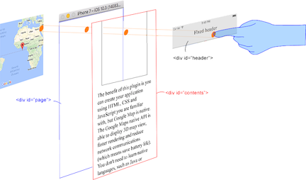
This plugin generates native map views, and put them under the browser.
The map views are not an HTML element. It means they are not kind of <div> or something.
But you can specify the size, position of the map view using <div>.
This plugin changes the background as transparent of your app.
Then the plugin detects your finger tap position which is for: native map or html element.

The benefit of this plugin is able to detect which HTML elements are over the map or not automatically.
In the below image, you tap on the header div, which is over the map view. This plugin detects your tap is for the header div or the map view, then pass the mouse event.
It means you can use the native Google Maps views similar like HTML element.
-
Google+ : (manager by @wf9a5m75)
-
Gitter : (manager by @Hirbod)
Thank you for supporting our activities.
The donated amount is used for buying testing machine (such as iPhone, Android) or new software.
Thank you for supporting us by bitcoin.
3LyVAfANZwcitEEnFbsHup3mDJfuqp8QFb


