Coder Social home page Coder Social logo

gpxtrackposter's Introduction

CI Format License MIT

GpxTrackPoster

Create a visually appealing poster from your GPX tracks - heavily inspired by https://www.instagram.com/p/Behppx9HCfx/

Usage

First of all, you need directory with a bunch of GPX files (e.g. you can export all your tracks from Garmin Connect with the excellent tool garmin-connect-export, or use StravaExportToGPX, or use runtastic, or use nrc-exporter to convert the activities in a Strava or Runtastic or Nike Run Club export zip file to GPX or GPX files).

You will need a little experience running things from the command line to use this script. That said, here are the usage details from the --help flag:

Get data from strava is ok now:

create_poster --from-strava strava.json --year 2020 --title "Running" \
    --athlete "Florian Pigorsch" --special 4110886680(strava id)

Only you need is change the strava config How to get strava config

usage: create_poster [-h] [--gpx-dir DIR] [--output FILE]
                     [--language LANGUAGE] [--localedir DIR] [--year YEAR]
                     [--title TITLE] [--athlete NAME] [--special FILE]
                     [--type TYPE] [--background-color COLOR]
                     [--track-color COLOR] [--track-color2 COLOR]
                     [--text-color COLOR] [--special-color COLOR]
                     [--special-color2 COLOR] [--units UNITS] [--clear-cache]
                     [--workers NUMBER_OF_WORKERS] [--from-strava FILE]
                     [--verbose] [--logfile FILE]
                     [--special-distance DISTANCE]
                     [--special-distance2 DISTANCE] [--min-distance DISTANCE]
                     [--activity-type ACTIVITY_TYPE] [--with-animation]
                     [--animation-time ANIMATION_TIME]
                     [--heatmap-center LAT,LNG] [--heatmap-radius RADIUS_KM]
                     [--heatmap-line-transparency-width TRANSP_1,WIDTH_1, TRANSP_2,WIDTH_2, TRANSP_3,WIDTH_3]
                     [--circular-rings] [--circular-ring-color COLOR]
                     [--circular-ring-max-distance DISTANCE]

optional arguments:
  -h, --help            show this help message and exit
  --gpx-dir DIR         Directory containing GPX files (default: current
                        directory).
  --output FILE         Name of generated SVG image file (default:
                        "poster.svg").
  --language LANGUAGE   Language (default: english).
  --localedir DIR       The directory where the translation files can be found
                        (default: the system's locale directory).
  --year YEAR           Filter tracks by year; "NUM", "NUM-NUM", "all"
                        (default: all years)
  --title TITLE         Title to display.
  --athlete NAME        Athlete name to display (default: "John Doe").
  --special FILE        Mark track file from the GPX directory as special; use
                        multiple times to mark multiple tracks.
  --type TYPE           Type of poster to create (default: "grid", available:
                        "grid", "calendar", "heatmap", "circular", "github").
  --background-color COLOR
                        Background color of poster (default: "#222222").
  --track-color COLOR   Color of tracks (default: "#4DD2FF").
  --track-color2 COLOR  Secondary color of tracks (default: none).
  --text-color COLOR    Color of text (default: "#FFFFFF").
  --special-color COLOR
                        Special track color (default: "#FFFF00").
  --special-color2 COLOR
                        Secondary color of special tracks (default: none).
  --units UNITS         Distance units; "metric", "imperial" (default:
                        "metric").
  --clear-cache         Clear the track cache.
  --workers NUMBER_OF_WORKERS
                        Number of parallel track loading workers (default:
                        number of CPU cores)
  --from-strava FILE    JSON file containing config used to get activities
                        from strava
  --verbose             Verbose logging.
  --logfile FILE
  --special-distance DISTANCE
                        Special Distance1 by km and color with the
                        special_color
  --special-distance2 DISTANCE
                        Special Distance2 by km and color with the
                        special_color2
  --min-distance DISTANCE
                        min distance by km for track filter
  --activity-type ACTIVITY_TYPE, --activity ACTIVITY_TYPE
                        Filter tracks by activity type; e.g. 'running'
                        (default: all activity types)
  --with-animation      add animation to the poster
  --animation-time ANIMATION_TIME
                        animation duration (default: 30s)

Heatmap Type Options:
  --heatmap-center LAT,LNG
                        Center of the heatmap (default: automatic).
  --heatmap-radius RADIUS_KM
                        Scale the heatmap such that at least a circle with
                        radius=RADIUS_KM is visible (default: automatic).
  --heatmap-line-transparency-width TRANSP_1,WIDTH_1, TRANSP_2,WIDTH_2, TRANSP_3,WIDTH_3
                        Define three transparency and width tuples for the
                        heatmap lines or set it to `automatic` for automatic
                        calculation (default: 0.1,5.0, 0.2,2.0, 1.0,0.3).

Circular Type Options:
  --circular-rings      Draw distance rings.
  --circular-ring-color COLOR
                        Color of distance rings.
  --circular-ring-max-distance DISTANCE
                        Maximum distance for scaling the track lengths (in
                        given units).

Example:

create_poster --from-strava strava.json --type circular
create_poster --type grid --gpx-dir "my-tracks" --language "de" --year 2015 --title "Running" \
    --athlete "Florian Pigorsch" --special race1.gpx --special race2.gpx --special race3.gpx

create_poster --type github --gpx-dir "my-tracks" --language "de" --title "Running" \
    --athlete "Florian Pigorsch" --special-distance 10 --special-distance2 10 --special-color yellow --special-color2 red

creates a nice poster (poster.svg) of the GPX tracks in the directory my-tracks (see above).

Selection of Tracks

create_poster tries to load all GPX files in the specified directory (option --gpx-dir). To speed up subsequent executions of the script, successfully loaded GPX tracks are cached in an intermediate format that allows for fast loading; use the option --clear-cache to delete these files. Tracks without time stamps and tracks recorded in the wrong year (option --year) are discarded. Tracks shorter than 1km are discarded, too If multiple tracks have been recorded within one hour, they are merged to a single track.

Filtering activities --from-strava FILE by activity_type

When using --from-strava FILE option, you may specify optional activity_type to filter only certain type(s) of activity to load. Note, activity_type filters activities only when loading from strava, and will not affect what already cached. That means if you change the value of activity_type you have to use --clear-cache to reload with the new filter. You can provide activity_type with a list or a string. All following examples are valid.

{
    "client_id": "YOUR STRAVA API CLIENT ID",
    "client_secret": "YOUR STRAVA API CLIENT SECRET",
    "refresh_token": "YOUR STRAVA REFRESH TOKEN",
    "activity_type": "Run"
}
{
    "client_id": "YOUR STRAVA API CLIENT ID",
    "client_secret": "YOUR STRAVA API CLIENT SECRET",
    "refresh_token": "YOUR STRAVA REFRESH TOKEN",
    "activity_type": ["Walk", "Hike"]
}
{
    "client_id": "YOUR STRAVA API CLIENT ID",
    "client_secret": "YOUR STRAVA API CLIENT SECRET",
    "refresh_token": "YOUR STRAVA REFRESH TOKEN"
}

Poster Types

Using the --type command line parameter, you can specify which type of poster to create:

Grid Poster (--type grid)

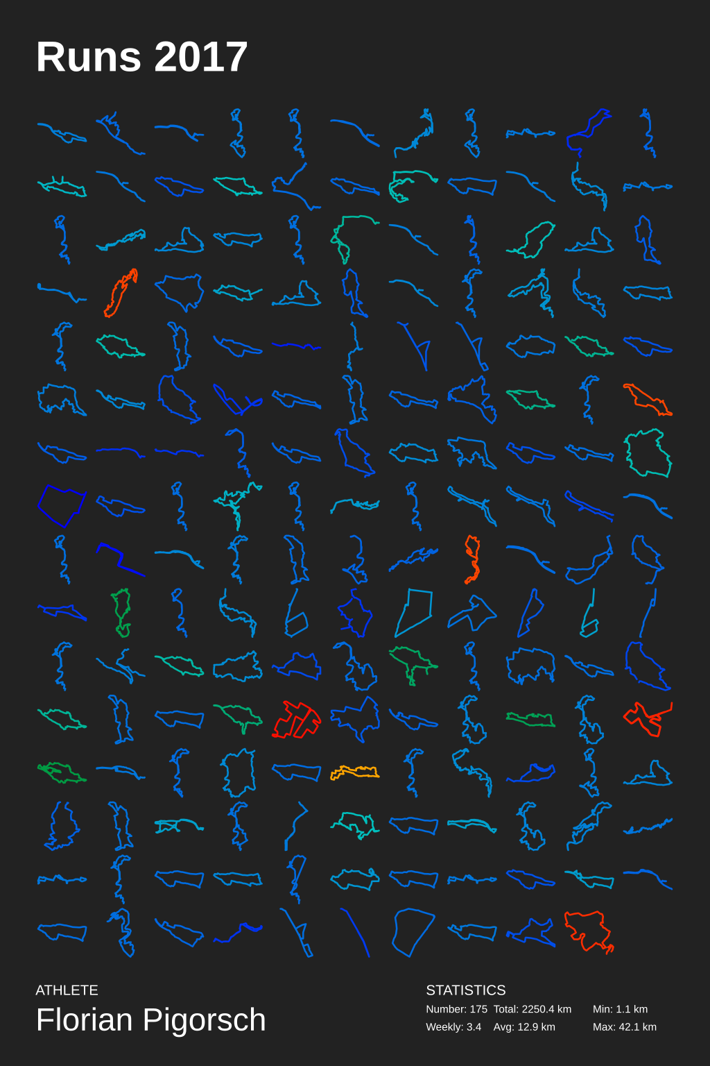
The Grid Poster layouts all tracks in a grid, starting with the earliest track in the upper left corner of the poster, continuing with the second earliest track to the left, and so on. Special tracks are drawn with the selected special color. Special distance tracks are drawn with the selected special color.

Example Grid Poster svg

Calendar Poster (--type calendar)

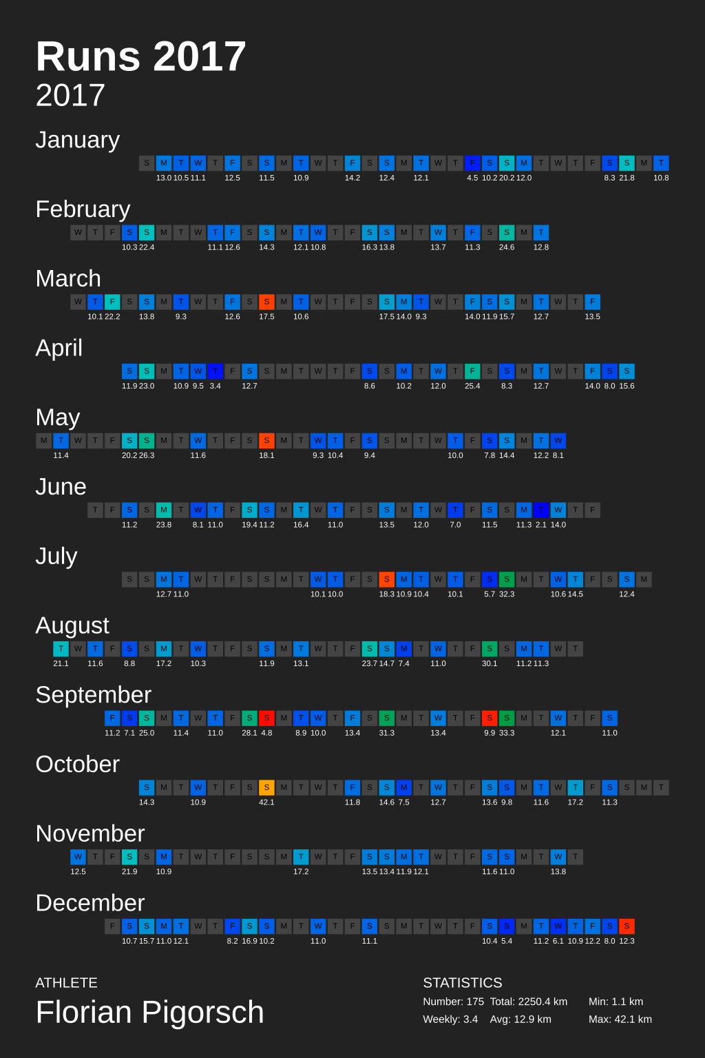
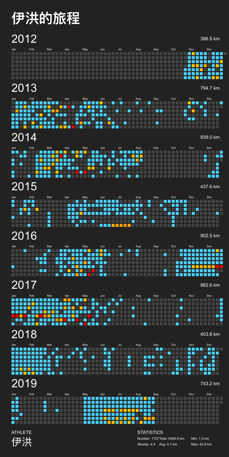
The Calendar Poster draws one square for each day, each row of squares corresponds to specific month. If a track was recorded of a day the corresponding square is colored with the track color or with the special color if the track is marked as special. A day's total track length in kilometers is printed below each square.

Example Calendar Poster svg

Circular Poster (--type circular)

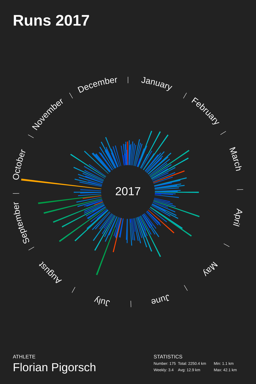
The Circular Poster the year in a circle; each day corresponds to a circle segment. The length of each segment corresponds to the total track distance of that day.

Example Circular Poster svg

Heatmap Poster (--type heatmap)

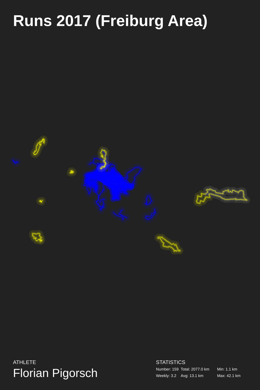
The Heatmap Poster displays all tracks within one "map". The more often a location has been "visited" on a track, the more colorful the corresponding location is on the map. Special tracks are drawn with the special color.

Example Heatmap Poster svg

Github Poster (--type github)

The Github Poster displays all tracks like github profile. Special distance are drawn with the special color.

Example Github Poster svg

Selection a Language

create_poster uses gettext to provide localization to other languages. To select a different language than the default English, use the --language LANGUAGE option. We currently support

  • French (--language fr_FR)
  • German (--language de_DE)
  • Chinese (--language zh_CN)
  • Russian (--language ru_RU)
  • Finnish (--language fi_FI)

Setup

  1. Clone the repository: git clone https://github.com/flopp/GpxTrackPoster.git
  2. cd GpxTrackPoster
  3. Create virtualenv: virtualenv -p /usr/bin/python3 venv or python -m venv venv
  4. Activate virtualenv: source venv/bin/activate
  5. Install the package: pip install .
  6. Install development requirements (only if you want to contribute code!): pip install -r requirements-dev.txt
  7. Run create_poster (see above)
  8. Deactivate virtualenv: deactivate

Contributing

If you have found a bug or have a feature request, please create a new issue. I'm always happy improve the implementation!

Or even better: clone the repo, fix the bug/implement the feature yourself, and file a pull request. Contributions are always welcome!

Important: If you want to contribute via a pull request, make sure you run make lint and possibly make format and make update-readme before pushing code.

Translation

The translation is based on GNUs 'gettext'. For the translation of the month names to work, the language must be installed.

Use locale -a to check if the language is installed.

Use locale-gen ru_RU.UTF-8 to install another language and update the locale update-locale.

Add new translation

Example: msginit --input=gpxposter.pot --locale=de_DE --output=locale/de_DE/LC_MESSAGES/gpxposter.po

Update a translation

E.g. use Poedit or Localise Online Editor to edit the "po" files. Afterwards compile that files.

Create compiled translation file

msgfmt gpxposter.po -o gpxposter.mo

License

MIT © 2016-2023 Florian Pigorsch

gpxtrackposter's People

Contributors

codeferricode avatar davidmerrick avatar djailla avatar flopp avatar joetimmerman avatar laufhannes avatar lowtower avatar mipapo avatar runalyze-system avatar sikmir avatar yekcim avatar yihong0618 avatar

Stargazers

 avatar  avatar  avatar  avatar  avatar  avatar  avatar  avatar  avatar  avatar  avatar  avatar  avatar  avatar  avatar  avatar  avatar  avatar  avatar  avatar  avatar  avatar  avatar  avatar  avatar  avatar  avatar  avatar  avatar  avatar  avatar  avatar  avatar  avatar  avatar  avatar  avatar  avatar  avatar  avatar  avatar  avatar  avatar  avatar  avatar  avatar  avatar  avatar  avatar  avatar  avatar  avatar  avatar  avatar  avatar  avatar  avatar  avatar  avatar  avatar  avatar  avatar  avatar  avatar  avatar  avatar  avatar  avatar  avatar  avatar  avatar  avatar  avatar  avatar  avatar  avatar  avatar  avatar  avatar  avatar  avatar  avatar  avatar  avatar  avatar  avatar  avatar  avatar  avatar  avatar  avatar  avatar  avatar  avatar  avatar  avatar  avatar  avatar  avatar  avatar

Watchers

 avatar  avatar  avatar  avatar  avatar  avatar  avatar  avatar  avatar  avatar  avatar  avatar  avatar  avatar  avatar  avatar

gpxtrackposter's Issues

feature: heatmap years to svg layers

when drawing heatmap with several years, separate each year in layers could be great (same scale, can enable or disable easily in svg editor…)

Configurable (or automatic) line width for heatmap

As already stated in #7, the heatmap is kind of useless if the track collection is wide spread. Still, I'm a big fan of having a look at my complete route net.

My current solution is to reduce line widths by hand, e.g.

for line in scaled_lines:
    d.add(d.polyline(points=line, stroke=color, stroke_opacity=0.02, fill='none', stroke_width=0.5, stroke_linejoin='round', stroke_linecap='round'))
for line in scaled_lines:
    d.add(d.polyline(points=line, stroke=color, stroke_opacity=0.05, fill='none', stroke_width=0.2, stroke_linejoin='round', stroke_linecap='round'))
for line in scaled_lines:
    d.add(d.polyline(points=line, stroke=color, fill='none', stroke_width=0.05, stroke_linejoin='round', stroke_linecap='round'))
for line in scaled_lines_special:
    d.add(d.polyline(points=line, stroke=color_special, fill='none', stroke_width=0.05, stroke_linejoin='round', stroke_linecap='round'))

That is: 0.02, 0.5 and 0.05, 0.2 instead of 0.1, 5.0 and 0.2, 2.0 (for ~2.600 activities from Sweden till the Alps). A high resolution image is required, but it works.

Maybe it's possible to automatically calculate line widths based on d_y and d_x. We could define limits for the values (e.g. both version from above as upper and lower limit respectively).

Error while loading .../.gpx: Something went wrong when loading GPX

Getting an error when I run the following command:

create_poster --type grid --title "Strava Routes" --athlete "NAME"

I am running the command from a directory that contains all my .gpx files. Any idea why this is happening?

This is the error (it prints one time in terminal for each .gpx file):

Error while loading /Users/../Downloads/export_54211749/activities/5138491472.gpx: Something went wrong when loading GPX.

[heatmap] Optionally use map as background

Depending on the heatmap's size, it may be nice to see at least some basic map in the background.

I have a first working solution with laufhannes@ebb0823 and laufhannes/staticmaplite@3758e11, but that's not perfect. The main part within this repo is to calculate lat/lng bounds of the visible part. Afterwards, a static map is requested, saved locally and inserted. (Without saving it locally, inkscape is not able to embed the image when converting to png)

The staticmaplite repo is written in php, but it should be possible to transform it into python. Using Google Maps Static may even be better (but requires an API key; in general free for non-commercial and low traffic apps), as it's possible to individually style the map. I created one first try for such a style at snazzy maps.

If using Google Maps, calculation of the required zoom level and cropping the image (or calculating the exact size) has to be done within this repo.


As this testing has been done in my local runalyze-environment, the example is decorated with our brandings ;)

laufhannes-heatmap-alltime-test-carto-dark

And I guess this needs some additional padding within the draw area to not let tracks touch the border.

Circular layout

Add circular layout:

  • (360/365)° segments for each day
  • segment length = run length at that day
  • multiple runs at one day -> stacked segments

Locale install

pip install doesn't install locale folder into lib/python3.8/site-packages/gpxtrackposter/.

no distance color

create_poster --output "/tmp/gpx_circular_test.svg" --athlete Anthony --year 2019 --type circular --special-distance 10 --special-distance2 15 --circular-rings

gpx_circular_test_90dpi

Everything is blue…

How should I use --special-distance argument? Is that a bug or a lack of understanding?

When I use --special colored some tracks are in yellow as expected

Help needed

Dear,

I'm not very skilled in programming, but did my best to try to understand this.

After a long time I managed to clone repository and set it up. However i keep returning the error: "AttributeError: module 'pint' has no attribute 'quantity'. Did you mean: 'Quantity'?". And not getting any output.

I tried my best to see where it went wrong, but couldnt find it.

If you could help me that would be wonderful.

Note: i cloned repository in visual study code, then set it up with "source venv\Scripts\activate.bat" instead of "source venv/bin/activate" then created a folder in the repository with all my gpx files retrieved from strava

feature: web interface with flask

Can we add this feature?

Add a link of svg file that user can select value or type value in form.
Add a generate button that can generate the svg file to show in the broswer.

I think flask is enough when click the button then cli side will generate the svg

Add BBox Option to Heatmap Poster

Add bbox option (--bbox COORDS1;COORDS2) to restrict the extent of the heatmap poster.

Rationale: if there are some tracks in your collection that are far away from the other tracks (e.g. runs during vacation), the heatmap poster becomes useless.

Idea - calendar|circular color intensity

The longer the distance the more intensive the color of that day

(Just looking at the posters all the time and wanna leave some ideas for peple who wanna contribute to this great repository ;) )

Heatmap bbox from clustering

Decided to try tackling #7 by using DBSCAN to cluster the (center points of the) tracks, then only create the heatmap for the first cluster. The code is very messy right now -- just a PoC to see if I could get it work -- and I'm not an expert on clustering algorithms, but it seems to be working well enough for me. Without customizing the heatmap center/radius, my heatmap was gibberish. Adding in the clustering, I get this nice result:

selection_002

If anyone wants to give it a try, it's in my fork -- I'd love to hear feedback/if it works for data other than mine. I've included a new requirements file, requirements-with-cluster.txt. The only changes are to heatmap_drawer.py, where I've added a new variable _cluster, which can be toggled on or off. You can tweak the eps parameter of DBSCAN to get different cluster sizes -- I'd imagine a cyclist doing 200 mile rides might need this set differently than a runner.

Edit: These changes are now present in this branch of my fork, but nost master.

Running into "No tracks found"

Regardless if i use a fixed or relative path as --gpx-dir or double or single quotes, i seem to rund into the No tracks found problem. Is there a certain format expected from the GPX files? Mine gets exported as:

<gpx version="1.1" creator=" " xmlns="http://www.topografix.com/GPX/1/1" xmlns:xsi="http://www.w3.org/2001/XMLSchema-instance" xsi:schemaLocation="http://www.topografix.com/GPX/1/1 http://www.topografix.com/GPX/1/1/gpx.xsd">

Track Loader fails for GPX tracks without a "type"

The recent update for activity type filtering causes the import of GPX files without a "type" to fail. I am using this software to import GPX tracks from ForeFlight which have no type field in the track. Reverting to the prior commit solves the problem as does adding a type field to GPX file manually.

Thanks!

stravalib Authorization Error

I've updated the stock strava.json with my info from https://www.strava.com/settings/api, akin to

{
    "client_id": "12345",
    "client_secret": "somerandomcharacters",
    "refresh_token": "morerandomcharacters",
}

Then I run create_poster --from-strava strava.json --year 2023, but the process fails with an error in stravalib.
The error is stravalib.exc.AccessUnauthorized: Unauthorized: Authorization Error: [{'resource': 'AccessToken', 'field': 'activity:read_permission', 'code': 'missing'}].

On the Strava API page I also see an 'Access Token' for my account, do I have to enter that somewhere, too?

Incorrect case of month names

Month names are printed in the nominative case for all languages except Russian, where it should be январь instead of января in the example bellow, compare:

  • --language de_DE:
    out-de
  • --language en_US:
    out-en
  • --language fi_FI:
    out-fi
  • --language fr_FR:
    out-fr
  • --language ru_RU:
    out-ru

That's caused by:


Let's check it:

$ python
>>> from datetime import datetime
>>> import locale
>>> locale.setlocale(locale.LC_ALL, 'ru_RU.UTF-8')
'ru_RU.UTF-8'
>>> datetime.today().strftime('%B')
'сентября'

methods (--type github --type circular) do not work if there are more than one track.

Works if there is one file in the directory.

Doesn't work, there are 3 files in the directory.
create_poster --type circular

Creating poster of type circular with 2 tracks and storing it in file poster.svg...
Traceback (most recent call last):
File "/home/user/.local/bin/create_poster", line 10, in
sys.exit(main())
File "/home/user/.local/lib/python3.8/site-packages/gpxtrackposter/cli.py", line 277, in main
p.draw(drawers[args.type], args.output)
File "/home/user/.local/lib/python3.8/site-packages/gpxtrackposter/poster.py", line 169, in draw
self._draw_tracks(d, XY(self.width - 20, self.height - 30 - 30), XY(10, 30))
File "/home/user/.local/lib/python3.8/site-packages/gpxtrackposter/poster.py", line 194, in _draw_tracks
self.tracks_drawer.draw(d, g, size, offset)
File "/home/user/.local/lib/python3.8/site-packages/gpxtrackposter/circular_drawer.py", line 103, in draw
self._draw_year(dr, g_year, sub_size, offset + margin + cell_size * XY(x, y), year)
File "/home/user/.local/lib/python3.8/site-packages/gpxtrackposter/circular_drawer.py", line 174, in _draw_year
key_times_list = utils.make_key_times(year_count)
File "/home/user/.local/lib/python3.8/site-packages/gpxtrackposter/utils.py", line 121, in make_key_times
s = list(takewhile(lambda n: n < 1, itercount(0, 1 / year_count)))
ZeroDivisionError: division by zero

create_poster --type github

Creating poster of type github with 2 tracks and storing it in file poster.svg...
Traceback (most recent call last):
File "/home/user/.local/bin/create_poster", line 10, in
sys.exit(main())
File "/home/user/.local/lib/python3.8/site-packages/gpxtrackposter/cli.py", line 277, in main
p.draw(drawers[args.type], args.output)
File "/home/user/.local/lib/python3.8/site-packages/gpxtrackposter/poster.py", line 169, in draw
self._draw_tracks(d, XY(self.width - 20, self.height - 30 - 30), XY(10, 30))
File "/home/user/.local/lib/python3.8/site-packages/gpxtrackposter/poster.py", line 194, in _draw_tracks
self.tracks_drawer.draw(d, g, size, offset)
File "/home/user/.local/lib/python3.8/site-packages/gpxtrackposter/github_drawer.py", line 44, in draw
year_length_str = utils.format_float(self.poster.m2u(year_length))
File "/home/user/.local/lib/python3.8/site-packages/gpxtrackposter/poster.py", line 175, in m2u
return m.m_as(Units().km)
File "/home/user/.local/lib/python3.8/site-packages/pint/quantity.py", line 533, in m_as
return self.to(units).magnitude
File "/home/user/.local/lib/python3.8/site-packages/pint/quantity.py", line 741, in to
magnitude = self._convert_magnitude_not_inplace(other, *contexts, **ctx_kwargs)
File "/home/user/.local/lib/python3.8/site-packages/pint/quantity.py", line 690, in _convert_magnitude_not_inplace
return self._REGISTRY.convert(self._magnitude, self._units, other)
File "/home/user/.local/lib/python3.8/site-packages/pint/registry.py", line 1036, in convert
return self._convert(value, src, dst, inplace)
File "/home/user/.local/lib/python3.8/site-packages/pint/registry.py", line 1951, in _convert
return super()._convert(value, src, dst, inplace)
File "/home/user/.local/lib/python3.8/site-packages/pint/registry.py", line 1558, in _convert
return super()._convert(value, src, dst, inplace)
File "/home/user/.local/lib/python3.8/site-packages/pint/registry.py", line 1069, in _convert
raise DimensionalityError(src, dst, src_dim, dst_dim)
pint.errors.DimensionalityError: Cannot convert from 'dimensionless' (dimensionless) to 'kilometer' ([length])

TypeError: can't compare offset-naive and offset-aware datetimes

I try to generate a poster with some gpx files extracted from my garmin account.
I have downloaded the files using the proposed python script garmin-connect-export.
Now, I get the following error:

Traceback (most recent call last):
  File "~/GpxTrackPoster/venv/bin/create_poster", line 8, in <module>
    sys.exit(main())
  File "~/GpxTrackPoster/venv/lib/python3.7/site-packages/gpxtrackposter/cli.py", line 217, in main
    tracks = loader.load_tracks(args.gpx_dir)
  File "~/GpxTrackPoster/venv/lib/python3.7/site-packages/gpxtrackposter/track_loader.py", line 114, in load_tracks
    return self._filter_and_merge_tracks(tracks)
  File "~/GpxTrackPoster/venv/lib/python3.7/site-packages/gpxtrackposter/track_loader.py", line 169, in _filter_and_merge_tracks
    tracks = self._merge_tracks(tracks)
  File "~/GpxTrackPoster/venv/lib/python3.7/site-packages/gpxtrackposter/track_loader.py", line 176, in _merge_tracks
    tracks = sorted(tracks, key=lambda t1: t1.start_time())
TypeError: can't compare offset-naive and offset-aware datetimes

Is something wrong with my gpx files?
As said, they all come from the same source.

Thanks in advance,
LT.

TypeError: Too few parameters for typing.Generator

works until 2cf9558
breaks starting with 7842d42

(env) mpo@mpo-home:~/projects/flopp-GPX$ ./create_poster.py --type grid --gpx-dir "mytracks" --year 2017 --title "Running"Traceback (most recent call last):
  File "./create_poster.py", line 11, in <module>
    from src import track_loader
  File "/home/mpo/projects/flopp-GPX/src/track_loader.py", line 31, in <module>
    class TrackLoader:
  File "/home/mpo/projects/flopp-GPX/src/track_loader.py", line 156, in TrackLoader
    def __list_gpx_files(base_dir: str) -> typing.Generator[str]:
  File "/usr/lib/python3.6/typing.py", line 682, in inner
    return func(*args, **kwds)
  File "/usr/lib/python3.6/typing.py", line 1130, in __getitem__
    _check_generic(self, params)
  File "/usr/lib/python3.6/typing.py", line 662, in _check_generic
    ("many" if alen > elen else "few", repr(cls), alen, elen))
TypeError: Too few parameters for typing.Generator; actual 1, expected 3

Add Strava Import

Add a Strava import function (via stravalib).
It may be enough to fetch the activities overview which contains the actual activity tracks as stripped down "summary polylines".

decimal separator not translated

numbers are always displayed in english way "1234.5"

Could be great if we can choose numbers display with --language. In french, for exemple, we write "1 234,5"

something like

import locale
locale.setlocale(locale.LC_ALL, 'fr_FR.UTF-8')
'{0:n}'.format(1234.5)

?

github colors

create_poster --gpx-dir "gpx/" --track-color '#5599ff' --track-color2 '#ffd732' --output "/tmp/GPXPOSTER.svg" --title 2019-2020 --athlete Bob --type github --language fr_FR --year 2019-2020 --circular-rings; done;

Colors are not used in github. I use these colors for heatmap and circular. As you can see, there is too much yellow in github:

GPXPOSTER heatmap+circular 2019-2020_90dpi

(by the way, thanks a lot for gpxtrackposter ♥)

All years?

Hi there, can we get an option to show all years? Or more than one year at a time?

I would like to combine several years at a time on the grid and heatmaps at least (might be tougher on the calendar and circular modes).

Does not process gpx whose route is less than 1km

I generated different workouts. All workouts with a distance of less than one kilometer are skipped
No tracks found.
Many workouts can be less than 1km, such as walking or swimming.

Please add support for tracks with a distance of less than 1km.

another display: barcode

just an idea, what do you think about this display?

barcod_display

(i draw it manually, speed graphs are not beautiful here, not enough amplitude)

#BUG: concurrent.futures

First of all, thanks for your work on this project ,it's great. #_#.
but when i cloned this project ,and run my own dataset, bug happened to me, it reported:

python create_poster.py --type grid --gpx-dir "data" --year 2018 --title "Running" --athlete "youth" --special 1.gpx --special 2.gpx --special 3.gpx

objc[6009]: +[__NSPlaceholderDictionary initialize] may have been in progress in another thread when fork() was called.
objc[6008]: +[__NSPlaceholderDictionary initialize] may have been in progress in another thread when fork() was called.
objc[6009]: +[__NSPlaceholderDictionary initialize] may have been in progress in another thread when fork() was called. We cannot safely call it or ignore it in the fork() child process. Crashing instead. Set a breakpoint on objc_initializeAfterForkError to debug.
objc[6008]: +[__NSPlaceholderDictionary initialize] may have been in progress in another thread when fork() was called. We cannot safely call it or ignore it in the fork() child process. Crashing instead. Set a breakpoint on objc_initializeAfterForkError to debug.
objc[6007]: +[__NSPlaceholderDictionary initialize] may have been in progress in another thread when fork() was called.
Traceback (most recent call last):
  File "create_poster.py", line 165, in <module>
    main()
  File "create_poster.py", line 142, in main
    tracks = loader.load_tracks(args.gpx_dir)
  File "/Users/youth/project/GpxTrackPoster/gpxtrackposter/track_loader.py", line 92, in load_tracks
    loaded_tracks = self._load_tracks(remaining_file_names)
  File "/Users/youth/project/GpxTrackPoster/gpxtrackposter/track_loader.py", line 148, in _load_tracks
    t = future.result()
  File "/usr/local/Cellar/python/3.6.4_4/Frameworks/Python.framework/Versions/3.6/lib/python3.6/concurrent/futures/_base.py", line 425, in result
    return self.__get_result()
  File "/usr/local/Cellar/python/3.6.4_4/Frameworks/Python.framework/Versions/3.6/lib/python3.6/concurrent/futures/_base.py", line 384, in __get_result
    raise self._exception
concurrent.futures.process.BrokenProcessPool: A process in the process pool was terminated abruptly while the future was running or pending.

I don't have any idea where the bug fires.

typography translation

last thing I think that could be added in translation file : ":"
In french, always as example, we use " :" (there is a nbsp)

(thank you very much for your reactivity on my issues reports and pull request, that's great and pleasant)

Something went wrong when loading GPX

Hi, can someone help me getting this to run in native windows? All dependecies and venv work, but if i pass a gpx dir (that confirmed works on linux) i get the above error.The error is in track.py:76 except Exception as e: # raise TrackLoadError("Something went wrong when loading GPX.") from e Sadly that doesn't tell me much.

If i remove the exception, I end up with an assertion error in create_poster-script.py:11, in <module> load_entry_point('gpxtrackposter==0.1', 'console_scripts', 'create_poster')()
I'm not familiar with all that build framework around that script so any help or pointers would be appreciated, because i think it's not an issue with the script itself or gpxpy.

rename master branch to main

Hello @flopp,

I would highly appreciate it if the outdated name "master" for the main branch could be renamed to "main".
Since 1st of October 2020 for all new projects the default name is "main".
I know that it seems to be a useless effort, but I think it is also an important statement these days.

Cheers,
LT.

Circular rings are scaled wrong if no max distance is provided

I guess this issue exists since 3e297b8 / #82.

I'm not sure how the unit handling in python works, but in this part max_length is in km if provided as cli argument and in m otherwise. In my example, the division distance / max_length gives 0.00028... kilometer / meter, but it's 0.28... dimensionless when using distance.to_base_units() / max_length.to_base_units().

        min_length = length_range.lower()
        max_length = length_range.upper()
        if self._max_distance:
            max_length = self._max_distance
        assert min_length is not None
        assert max_length is not None
        ring_distance = self._determine_ring_distance(max_length)
        if ring_distance is None:
            return
        distance = ring_distance
        while distance < max_length:
            radius = radius_range.interpolate((distance / max_length).magnitude)

Not sure if there are more lines where this fails (or did I somehow misconfigured my units?).

Recommend Projects

  • React photo React

    A declarative, efficient, and flexible JavaScript library for building user interfaces.

  • Vue.js photo Vue.js

    🖖 Vue.js is a progressive, incrementally-adoptable JavaScript framework for building UI on the web.

  • Typescript photo Typescript

    TypeScript is a superset of JavaScript that compiles to clean JavaScript output.

  • TensorFlow photo TensorFlow

    An Open Source Machine Learning Framework for Everyone

  • Django photo Django

    The Web framework for perfectionists with deadlines.

  • D3 photo D3

    Bring data to life with SVG, Canvas and HTML. 📊📈🎉

Recommend Topics

  • javascript

    JavaScript (JS) is a lightweight interpreted programming language with first-class functions.

  • web

    Some thing interesting about web. New door for the world.

  • server

    A server is a program made to process requests and deliver data to clients.

  • Machine learning

    Machine learning is a way of modeling and interpreting data that allows a piece of software to respond intelligently.

  • Game

    Some thing interesting about game, make everyone happy.

Recommend Org

  • Facebook photo Facebook

    We are working to build community through open source technology. NB: members must have two-factor auth.

  • Microsoft photo Microsoft

    Open source projects and samples from Microsoft.

  • Google photo Google

    Google ❤️ Open Source for everyone.

  • D3 photo D3

    Data-Driven Documents codes.