Coder Social home page Coder Social logo

arcgis-toolkit-sl-wpf's Introduction

arcgis-toolkit-sl-wpf

This project contains the source code and libraries for the ArcGIS Runtime SDK Toolkit for Silverlight/WPF. The library is an extension of the ArcGIS API for Silverlight™ and the ArcGIS Runtime SDK for WPF™. Included are a number of controls, classes, and data sources you can use to enhance your applications.

NOTE: This library is only an extension of the ArcGIS API for Silverlight™ or the ArcGIS Runtime SDK for WPF™. In order to build a complete mapping application, you will also need to install the respective products on which they are built. See the instructions below on how to get started.

View it live in Silverlight

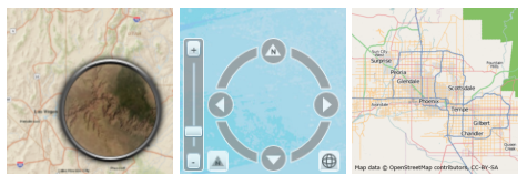
Example toolkit contents

Features

  • Controls and classes
  • AttachmentEditor
  • Attribution
  • Bookmark
  • EditorWidget
  • FeatureDataForm
  • FeatureDataGrid
  • InfoWindow
  • Legend
  • Magnifier
  • MagnifyingGlass
  • MapProgressBar
  • MapTip
  • Navigation
  • OAuthAuthorize
  • OverviewMap
  • SignInDialog
  • TemplatePicker
  • TimeSlider
  • Data sources
  • CsvLayer
  • GeoRssLayer
  • GpsLayer
  • HeatMapLayer
  • KmlLayer
  • OpenStreetMapLayer
  • WebTiledLayer
  • WmsLayer
  • WmtsLayer

Instructions

  1. Fork and then clone the repo or download the .zip file.
  2. Download and install the ArcGIS API for Silverlight or ArcGIS Runtime SDK for WPF. Login requires an Esri Global account, which can be created for free.
  1. In Visual Studio, open the solution for Silverlight (ESRI_Silverlight_Toolkit.sln) or WPF (ESRI_WPF_Toolkit.sln). You may need to update the reference to the location of the core ArcGIS Silverlight or WPF assembly ESRI.ArcGIS.Client.dll.
  2. Build the ESRI.ArcGIS.Client.Toolkit and ESRI.ArcGIS.Client.Toolkit.DataSources projects and reference the dlls in your application.

Requirements

Resources

Issues

Find a bug or want to request a new feature? Please let us know by submitting an issue.

Contributing

Anyone and everyone is welcome to contribute.

Licensing

Copyright 2013 Esri

Licensed under Ms-PL (the "License"); you may not use this file except in compliance with the License. You may obtain a copy of the License at

https://opensource.org/licenses/ms-pl

Unless required by applicable law or agreed to in writing, software distributed under the License is distributed on an "AS IS" BASIS, WITHOUT WARRANTIES OR CONDITIONS OF ANY KIND, either express or implied. See the License for the specific language governing permissions and limitations under the License.

A copy of the license is available in the repository's license.txt file.

[](Esri Tags: ArcGIS toolkit wpf silverlight c-sharp) [](Esri Language: Silverlight)

arcgis-toolkit-sl-wpf's People

Contributors

alaframboise avatar dbroux avatar dotmorten avatar kubaszostak avatar mbranscomb avatar rexhansen avatar

Stargazers

 avatar  avatar  avatar  avatar  avatar  avatar  avatar  avatar  avatar  avatar  avatar  avatar  avatar  avatar  avatar  avatar  avatar  avatar  avatar  avatar  avatar  avatar  avatar

Watchers

 avatar  avatar  avatar  avatar  avatar  avatar  avatar  avatar  avatar  avatar  avatar  avatar  avatar  avatar  avatar  avatar  avatar  avatar  avatar  avatar  avatar  avatar  avatar  avatar  avatar  avatar  avatar  avatar  avatar  avatar  avatar  avatar  avatar  avatar  avatar  avatar  avatar  avatar

arcgis-toolkit-sl-wpf's Issues

Unhandled exception when initializing WmsLayer

Unhandled exception is thrown when initializing WmsLayer with URL that points to invalid GetCapabilities XML document. Expected behaviour is to transfer this exception to WmsLayer.InitializationFailure property and fire WmsLayer.InitializationFailed event.

public MainPage()
{
    InitializeComponent();

    App.Current.UnhandledException += (sa, ea) => {
        ea.Handled = true;
        MessageBox.Show("Unhandled exception: " + ea.ExceptionObject.Message);
    };
    Legend.Map = this.Map;
}

private void Button_Click(object sender, RoutedEventArgs e)
{
    var wms = new WmsLayer();
    wms.ProxyUrl = "http://servicesbeta3.esri.com/SilverlightDemos/ProxyPage/proxy.ashx";
    wms.SkipGetCapabilities = false;

    wms.Url = "http://www.arcgis.com"; // Unhandled exception: The 'link' start tag on line 9 position 6 does not match the end tag of 'head'. Line 41, position 5.
    //wms.Url = "http://www.arcgis.com/crossdomain.xml"; // Unhandled exception: Sequence contains no elements
    //wms.Url = ""; //InitializationFailed: The remote server returned an error: NotFound.
    //wms.Url =  "http://wms.gdos.gov.pl/geoserver/wms?"; // No exception

    wms.InitializationFailed += (fs, fe) =>
    {
        MessageBox.Show("Wms initialization failed: " + wms.InitializationFailure.Message);
    };
    Map.Layers.Add(wms);
}

Load tiles of map through UTM projection

Dear all
Hi
I look at this link
arcgis-toolkit-sl-wpf/WebTiledLayer.cs at master · Esri/arcgis-toolkit-sl-wpf · GitHub

that is a remarkable link to get beneficial information for loading tile layer.
But as mentioned in this link, the values of cornerCoordinate and WKID are set only for mecator projection. I do not handle this code for UTM projection. how to change these parameters to use them in Utm Projection. please, guide me.
Best regards
Mary

Geometry, FeatureService reference not found.

CS0234 The type or namespace name 'Geometry' does not exist in the namespace 'ESRI.ArcGIS.Client' (are you missing an assembly reference?) ESRI.ArcGIS.Client.Toolkit.DataSources D:\arcgis-toolkit-sl-wpf-master\src\CommonAPI\API\ESRI.ArcGIS.Client.Toolkit.DataSources\Wmts\Wmts.cs 15 Active

I downloaded arcgis-toolkit-sl-wpf-master.zip and opened solution file in Visual Studio. I got above error building api.

Can someone help me with this?

image

Screenshot attached.

Meghan Kulkarni

WmtsLayer does not work with multi-dimensional WMTS Services

Hi
WMTS Services can be multi-dimensional. "In case of multi-dimensional data, the service metadata can describe their multi-dimensionality and tiles can be requested at specific values in these dimensions. Examples of dimensions are Time, Elevation and Band. Optional parameters in WMTS service metadata declare available values along one or more dimensional axes applicable to a Layer. GetTile and GetFeatureInfo requests for that layer should include parameters specifying dimensional value(s)." (http://www.opengeospatial.org/standards/wmts).

Unfortunately, the following XAML would normaly cause a Silverlight application to send incorrect requests to the specific WMTS:

<Grid x:Name="LayoutRoot" Background="White">
    <esri:Map WrapAround="True" x:Name="MyMap" >
        <esri:Map.Layers>
            <esri:WmtsLayer 
             Url="http://wmts.geo.admin.ch" 
             ServiceMode="RESTful" 
             Layer="ch.swisstopo.pixelkarte-farbe"/>

        </esri:Map.Layers>
    </esri:Map>
</Grid>

The incorrect request being sent is:
http://wmts.geo.admin.ch/1.0.0/ch.swisstopo.pixelkarte-farbe/default/{Time}/21781/13/1/1.jpeg

In contrast, a correct request would be like the following:
http://wmts.geo.admin.ch/1.0.0/ch.swisstopo.pixelkarte-farbe/default/20130903/21781/13/1/1.jpeg

The capabilities for the WMTS used above can be found here:
http://wmts.geo.admin.ch/1.0.0/WMTSCapabilities.xml

My temporary fix that seems to work for my application is limited to the following line of code in Wmts.cs (Line 1730):
url = url.Replace("{Time}", "20140106");

It would be great if somebody could fix this!
Marcel

WmsLayer.SetLayerVisibility() is inaccessible for tree style child layers

If WmsLayer contains tree-style child layers there is no way to set this child layers visibility.

img

private void Sublayer_Click(object sender, RoutedEventArgs e)
{
    var wms = new WmsLayer();
    wms.ProxyUrl = "http://servicesbeta3.esri.com/SilverlightDemos/ProxyPage/proxy.ashx";
    wms.SkipGetCapabilities = false;

    wms.Url = "http://mapy.geoportal.gov.pl/wss/service/img/guest/TOPO/MapServer/WMSServer";

    wms.InitializationFailed += (fs, fe) =>
    {
        MessageBox.Show("Wms initialization failed: " + wms.InitializationFailure.Message);
    };

    wms.Initialized += wms_Initialized;
    Map.Layers.Add(wms);
}

void wms_Initialized(object sender, EventArgs e)
{
    var wms = sender as WmsLayer;
    if ((wms == null) || (wms.InitializationFailure !=null))
        return;

    //  http://mapy.geoportal.gov.pl/wss/service/img/guest/TOPO/MapServer/WMSServer
    //  |
    //  |- Mapy_Topograficzne
    //     |
    //     |- Raster

    foreach (var layer in wms.LayerList)
    {
        foreach (var childLayer in layer.ChildLayers)
        {
            if (childLayer.Title.Contains("Raster"))
            {
                //wms.SetLayerVisibility(childLayer.SubLayerID, true); // internal int SubLayerID { get; set; }
            }

        }
    }
}

Recommend Projects

  • React photo React

    A declarative, efficient, and flexible JavaScript library for building user interfaces.

  • Vue.js photo Vue.js

    🖖 Vue.js is a progressive, incrementally-adoptable JavaScript framework for building UI on the web.

  • Typescript photo Typescript

    TypeScript is a superset of JavaScript that compiles to clean JavaScript output.

  • TensorFlow photo TensorFlow

    An Open Source Machine Learning Framework for Everyone

  • Django photo Django

    The Web framework for perfectionists with deadlines.

  • D3 photo D3

    Bring data to life with SVG, Canvas and HTML. 📊📈🎉

Recommend Topics

  • javascript

    JavaScript (JS) is a lightweight interpreted programming language with first-class functions.

  • web

    Some thing interesting about web. New door for the world.

  • server

    A server is a program made to process requests and deliver data to clients.

  • Machine learning

    Machine learning is a way of modeling and interpreting data that allows a piece of software to respond intelligently.

  • Game

    Some thing interesting about game, make everyone happy.

Recommend Org

  • Facebook photo Facebook

    We are working to build community through open source technology. NB: members must have two-factor auth.

  • Microsoft photo Microsoft

    Open source projects and samples from Microsoft.

  • Google photo Google

    Google ❤️ Open Source for everyone.

  • D3 photo D3

    Data-Driven Documents codes.