Coder Social home page Coder Social logo

albar965 / littlenavmap Goto Github PK

View Code? Open in Web Editor NEW
1.3K 64.0 163.0 357.6 MB

Little Navmap is a free flight planner, navigation tool, moving map, airport search and airport information system for Flight Simulator X, Microsoft Flight Simulator 2020, Prepar3D and X-Plane.

Home Page: https://albar965.github.io/littlenavmap.html

License: GNU General Public License v3.0

Shell 0.99% HTML 12.45% QMake 0.63% CSS 0.30% C++ 84.32% Batchfile 0.35% JavaScript 0.74% Inno Setup 0.21%
navigation flight simulator map flightplan fsx prepar3d x-plane flightplanner msfs

littlenavmap's Introduction

Latest Stable Release

► Windows 64-bit Installer (MSFS and X-Plane) - LittleNavmap-win64-3.0.9-Install.exe
► macOS - LittleNavmap-macOS-3.0.9.zip
► Linux (64 bit, based on Ubuntu 22.04) - LittleNavmap-linux-ubuntu-22.04-3.0.9.tar.xz
► Linux Debian Installation Package (64 bit, based on Ubuntu 22.04) - LittleNavmap-linux-ubuntu-22.04-3.0.9-1_amd64.deb

Other Versions:

► Windows 32-bit Installer (only for FSX and P3D) - LittleNavmap-win32-3.0.9-Install.exe
► Linux (64 bit, based on Ubuntu 20.04 for Debian or older systems) - LittleNavmap-linux-ubuntu-20.04-3.0.9.tar.xz
► Linux Debian Installation Package (64 bit, based on Ubuntu 20.04) - LittleNavmap-linux-ubuntu-20.04-3.0.9-1_amd64.deb

Zipped Windows releases without installer are available in the alternative download locations below or from the release assets at GitHub - Little Navmap Releases - Version 3.0.9 (scroll down to Assets).

Alternative Download Locations

Little Navmap Links

► Screenshots for Little Navmap

► Screenshots of new 2.8 Features

► User manuals for Little Navmap and Little Navconnect


► Other Downloads (SimConnect, Aircraft Performance and more)

Little Navmap - Frequently asked Questions

Little Navmap - Install Navigraph Updates Shows how to update the included Navigraph database to the latest cycle.

► GitHub Profile All my projects, releases, source code, issue lists and more.

► Support Forum at Avsim Support and help for users.

Little Navmap Donations

Donate

Donate to show your appreciation if you like my programs. Spenden Sie, um Ihre Wertschätzung zu zeigen, wenn Ihnen meine Programme gefallen.

Little Navmap

Little Navmap Little Navmap is a free open source flight planner, navigation tool, moving map, airport search and airport information system for Flight Simulator X, Prepar3D, Microsoft Flight Simulator 2020 and X-Plane and is available for Windows, Apple macOS and Linux.

Little Navmap comes with a detailed manual also including tutorials which is available online as well as in PDF and other formats like EPUB. Help buttons in all relevant areas of the program display corresponding chapters in the online manual on click.

Little Navmap 2.2.2 spherical map projection and elevation profile with flight plan

Little Navmap 2.2.2 sun shadow on globe

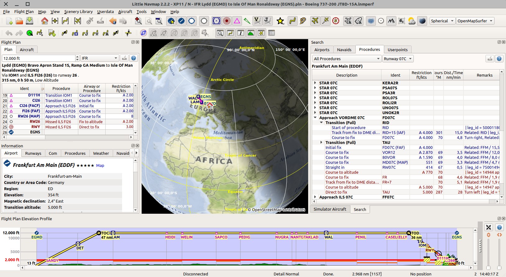
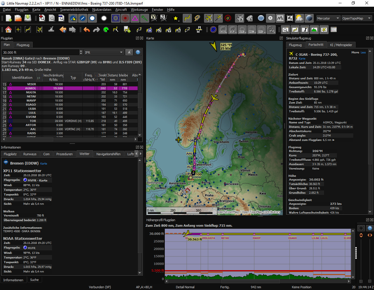
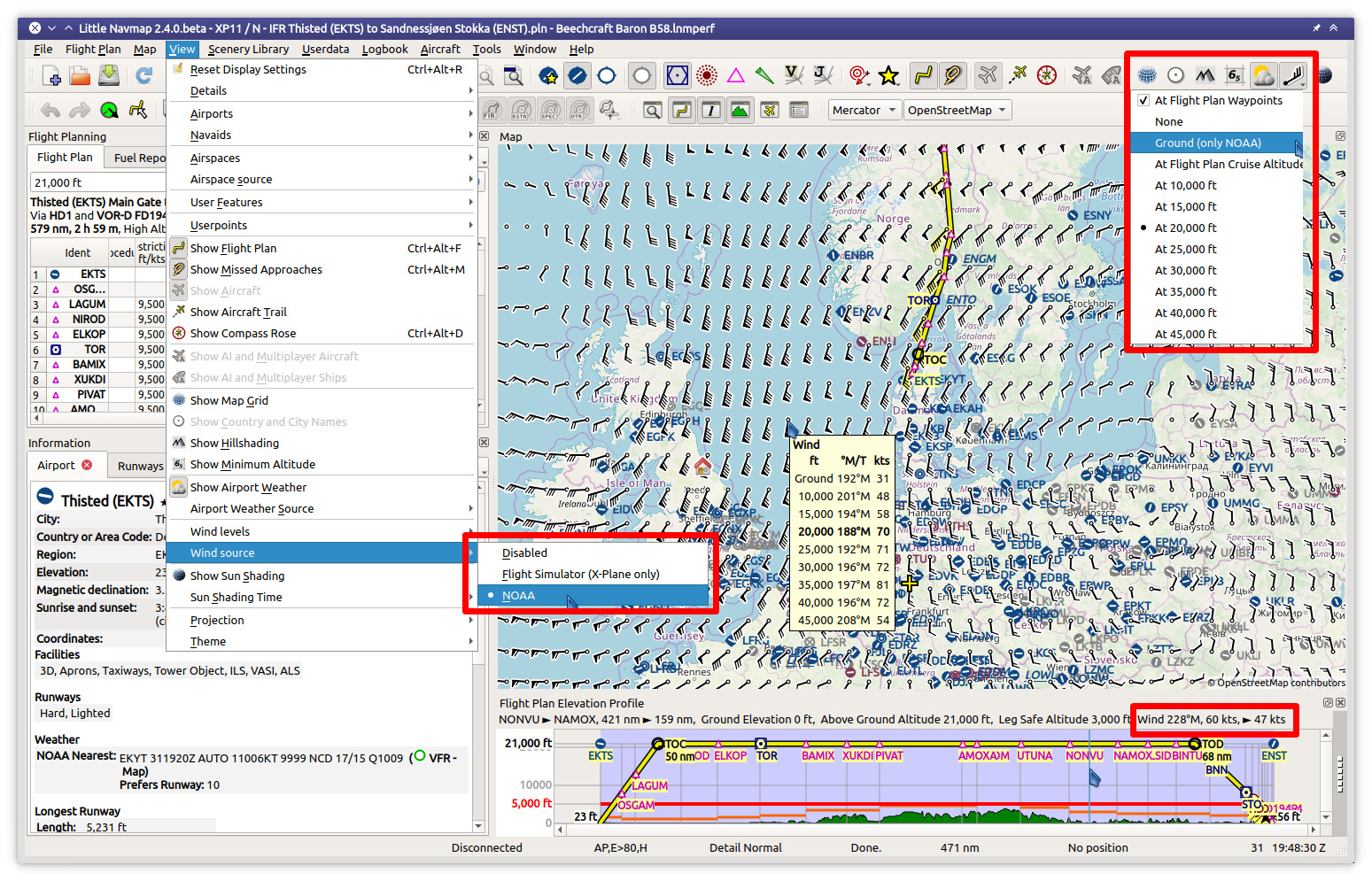
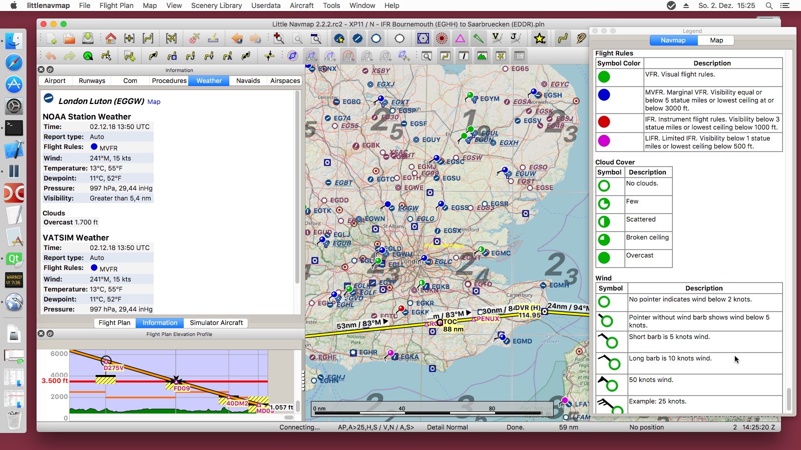
A widely configurable map display using the OpenStreetMap as a background map which is only one option of many online and included offline maps. The map shows airports, navaids, airways, airspaces, oceanic tracks, high altitude winds, AI or multiplayer aircraft and ships as well as airport weather, winds aloft and a minimum off-route altitude grid (MORA). A seamlessly integrated airport diagram displays taxiways, displaced thresholds, overrun areas, aprons, parking spots and more.

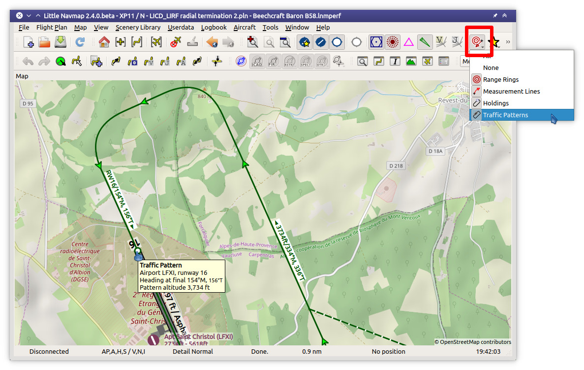
User can place airport traffic patterns or holdings as a visual guidance on the map.

Little Navmap 2.4.4 winds aloft

Little Navmap 2.4.4 User Features

It supports approach and departure procedures like SIDs, STARs, custom final approaches, offers a widely configurable automatic flight plan calculation and several export formats like GFP (Reality XP GTN and Flight1 GTN), FPL (Reality XP GNS), GPX, RTE, FLP and X-Plane FMS as well as drag and drop flight plan editing on the map. The program can read the PLN, FMS and FLP and more flight plan formats.

Several flight plan formats can be exported using the flight plan multiexport feature with one click.

Keyboard shortcuts help to access most functions without mouse.

An elevation profile is shown for the flight plan allowing to find a safe cruise altitude also displaying top of climb, top of descent and procedure altitude restrictions. Calculated and shown climb as well as descent paths adhere to altitude restrictions.

Aircraft performance and fuel planning is included which automatically considers winds aloft for fuel, top of climb and top of descent calculation. Performance values can be collected automatically during flight and can be merged into the currently profile at any time.

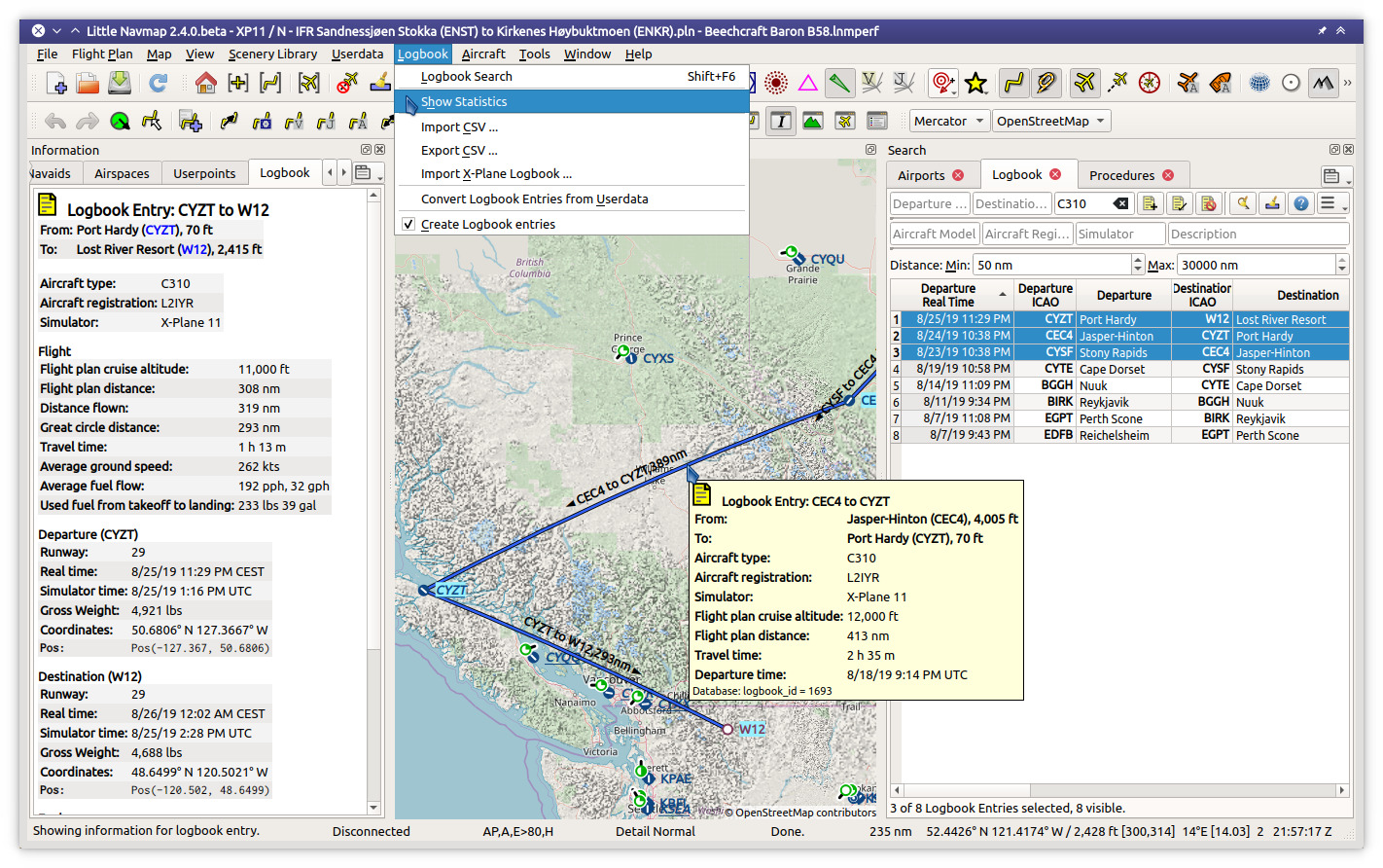
Search functionality allows to look for airports, navaids, procedures, user defined waypoints and logbook entries by a large amount of criteria also including a spatial search.

Userpoint functionality allow to place, edit and export user defined features like points of interest, visual reporting points and more on the map. Import and export of CSV, X-Plane and Garmin files.

Little Navmap comes with its own logbook allowing to automatically record, search and edit logbook entries. The logbook records the flight plan and the flown track which can be exported to GPX files.

Oceanic and other tracks like NAT can be downloaded, shown on the map and can be used for automatic flight plan calculation.

Little Navmap 2.4.4 Logbook

Little Navmap 2.2.2 Airport Weather

The program can generate an ATS route description from flight plans and vice versa where the output is widely configurable.

A cycle 1801 database courtesy of Navigraph is included in the download and includes navaids, airways, airspaces, procedures and more. The navigation data can be updated by the Navigraph FMS Data Manager.

Display of clients and centers of VATSIM, IVAO, PilotEdge and custom online networks.

Little Navmap features its own internal web server which allows to follow aircraft progress from any device across a network.

Supported Flight Simulators: All FSX versions from SP2 up, Flight Simulator - Steam Edition, Prepar3D v4, v5, v6, Microsoft Flight Simulator 2020, X-Plane 11 and X-Plane 12.

Supported platforms: Windows 7/8/10/11, Apple macOS (10.12 or newer only) and Linux (64 bit only).

Little Navmap

littlenavmap's People

Contributors

albar965 avatar harveywalker500 avatar j0hnliu avatar jonaseberle avatar kant avatar kokaproduktion avatar prinz7 avatar saj avatar tonghuix avatar u-an-i avatar

Stargazers

 avatar  avatar  avatar  avatar  avatar  avatar  avatar  avatar  avatar  avatar  avatar  avatar  avatar  avatar  avatar  avatar  avatar  avatar  avatar  avatar  avatar  avatar  avatar  avatar  avatar  avatar  avatar  avatar  avatar  avatar  avatar  avatar  avatar  avatar  avatar  avatar  avatar  avatar  avatar  avatar  avatar  avatar  avatar  avatar  avatar  avatar  avatar  avatar  avatar  avatar  avatar  avatar  avatar  avatar  avatar  avatar  avatar  avatar  avatar  avatar  avatar  avatar  avatar  avatar  avatar  avatar  avatar  avatar  avatar  avatar  avatar  avatar  avatar  avatar  avatar  avatar  avatar  avatar  avatar  avatar  avatar  avatar  avatar  avatar  avatar  avatar  avatar  avatar  avatar  avatar  avatar  avatar  avatar  avatar  avatar  avatar  avatar  avatar  avatar  avatar

Watchers

 avatar  avatar  avatar  avatar  avatar  avatar  avatar  avatar  avatar  avatar  avatar  avatar  avatar  avatar  avatar  avatar  avatar  avatar  avatar  avatar  avatar  avatar  avatar  avatar  avatar  avatar  avatar  avatar  avatar  avatar  avatar  avatar  avatar  avatar  avatar  avatar  avatar  avatar  avatar  avatar  avatar  avatar  avatar  avatar  avatar  avatar  avatar  avatar  avatar  avatar  avatar  avatar  avatar  avatar  avatar  avatar  avatar  avatar  avatar  avatar  avatar  avatar  avatar  avatar

littlenavmap's Issues

Error loading S720_AGN_Trees.BGL in FSXSE

[2016-10-01 15:23:51.431 default INFO ]  unknown:0: ==== "3756 of 13617 (27 %)" "S720_AGN_Trees.BGL"
[2016-10-01 15:23:51.438 default WARN ]  unknown:0: Invalid magic number 1: 0x1e950506, 2: f021f04
[2016-10-01 15:23:51.499 default CRIT ]  unknown:0: Caught exception: readInt for file "E:/Steam/steamapps/common/FSX/Scenery/Global/scenery/S720_AGN_Trees.BGL" failed. Reason 1

Flight plan transfer to flight simulator and back

Once the flight plan changes in Navmap automatically copy it to FSX computer and call
SimConnect_FlightPlanLoad.

If a flight plan changes in the simulator load it:
SimConnect_SubscribeToSystemEvent with FlightPlanActivated parameter.

Check if this is also doable for X-Plane.

Use Active Sky route weather

Use Active Sky route weather file if route is loaded which gives slightly different metars compared to the wx snapshot.

Indicators in search panel

Add an indicator in the search panel that shows if all search parameters are default.
Add an indicator for each line (i.e. red vertical bar or red frame around changed widget) .

Invalid route type if route is built manually

Flight plan type can be empty if plan was build manually.

As a workaround calculate a Victor (or something else) plan after setting departure and destination. Then do "Calculate Direct". This will add the correct value "Direct" to the RouteType.

Add dark theme

Use black and white map theme and draw a semi transparent overlay to make the map darker.
https://gist.github.com/Skyrpex/5547015

qApp->setStyle(QStyleFactory::create("fusion"));
QPalette palette;
palette.setColor(QPalette::Window, QColor(53,53,53));
palette.setColor(QPalette::WindowText, Qt::white);
palette.setColor(QPalette::Base, QColor(15,15,15));
palette.setColor(QPalette::AlternateBase, QColor(53,53,53));
palette.setColor(QPalette::ToolTipBase, Qt::white);
palette.setColor(QPalette::ToolTipText, Qt::white);
palette.setColor(QPalette::Text, Qt::white);
palette.setColor(QPalette::Button, QColor(53,53,53));
palette.setColor(QPalette::ButtonText, Qt::white);
palette.setColor(QPalette::BrightText, Qt::red);
palette.setColor(QPalette::Highlight, QColor(142,45,197).lighter());
palette.setColor(QPalette::HighlightedText, Qt::black);
palette.setColor(QPalette::Disabled, QPalette::Text, Qt::darkGray);
palette.setColor(QPalette::Disabled, QPalette::ButtonText, Qt::darkGray);
qApp->setPalette(palette);

alternative:

qApp->setStyle(QStyleFactory::create("Fusion"));

QPalette darkPalette;
darkPalette.setColor(QPalette::Window, QColor(53,53,53));
darkPalette.setColor(QPalette::WindowText, Qt::white);
darkPalette.setColor(QPalette::Base, QColor(25,25,25));
darkPalette.setColor(QPalette::AlternateBase, QColor(53,53,53));
darkPalette.setColor(QPalette::ToolTipBase, Qt::white);
darkPalette.setColor(QPalette::ToolTipText, Qt::white);
darkPalette.setColor(QPalette::Text, Qt::white);
darkPalette.setColor(QPalette::Button, QColor(53,53,53));
darkPalette.setColor(QPalette::ButtonText, Qt::white);
darkPalette.setColor(QPalette::BrightText, Qt::red);
darkPalette.setColor(QPalette::Link, QColor(42, 130, 218));

darkPalette.setColor(QPalette::Highlight, QColor(42, 130, 218));
darkPalette.setColor(QPalette::HighlightedText, Qt::black);

qApp->setPalette(darkPalette);

qApp->setStyleSheet("QToolTip { color: #ffffff; background-color: #2a82da; border: 1px solid white; }");

Support FSX approaches and transitions

  • Allow user to select approaches and transition from FSX stock data
  • Draw these on the map
  • Add waypoints to flight plan
  • Save selected appr and trans as a look-aside file besides PLN

Allow to switch metric/imperial/nautical units

Allow to switch units:

  • Meter, km, km/h
  • Feet, miles, miles/h
  • Feet, nautical miles, knots
    For altitude, speed, distance.

The same for coordinate formats:

  • Deg/min/sec format
  • Decimal format

Additionally change shortened runway length in map display to full number and unit.
Change pressure from mbar to hPa.

FSX SE not correctly recognized

[2016-10-01 15:16:51.884 default DEBUG]  unknown:0: Found a flight simulator base path for type atools::fs::FsPaths::SimulatorType(FSX) at "E:\\Steam\\steamapps\\common\\FSX"
[2016-10-01 15:16:51.885 default DEBUG]  unknown:0: Found a flight simulator base path for type atools::fs::FsPaths::SimulatorType(FSX_SE) at ""
[2016-10-01 15:16:51.885 default DEBUG]  unknown:0: Found a flight simulator base path for type atools::fs::FsPaths::SimulatorType(P3D_V2) at ""
[2016-10-01 15:16:51.885 default DEBUG]  unknown:0: Found a flight simulator base path for type atools::fs::FsPaths::SimulatorType(P3D_V3) at ""
[2016-10-01 15:16:51.885 default DEBUG]  unknown:0: atools::fs::FsPaths::SimulatorType(FSX) FsPathType[registry entry true, has database false, base path "E:\\Steam\\steamapps\\common\\FSX", scenery config "c:\\Documents And Settings\\All Users\\Application Data\\Microsoft\\FSX\\Scenery.CFG"]

Exchange flightplan as ICAO route string

Like: EDDS TAU EDDK
Add menu item that copies the flight plan in short format to the clipboard and
another function that allows to enter the text format for a flight plan.

Add HTML export

Export the content of the route table view and a selectable map excerpt to a HTML document which can also be printed directly using the Qt printing API.

Add wind pointer to map

Use a overlay or paint directly the wind direction on the map for the user aircraft if active.
Option to switch it off.
Alternatively (optional) paint wind pointer directly at the user aircraft.

Add user waypoint and bookmark managment

Export to Garmin user.wpt and X-Plane user_wpt.dat. Maybe a bglcompiler XML too.

Store custom waypoints in the database and allow export and import to CSV.

What I'd like to see added is a possibility to show the Project Tupolev, SCS and SamDim plane RSBN beacons from the two used types of databases.

Proposal from Paul:

Ability to add user defined waypoints to LNM and have these automatically loaded when creating a new database so that they are persistent and not deleted each time you reload the flight sim data.

Allow to set locale for number format in CSV file.

More ideas for bookmarks:
Add editable comment column to airport.
Add editable tabs to airport.

Load and export X-Plane user_fix.dat

Support a cloud database.

Set timestamp of last change.

Examples:
airspace_and_userdefined_points_example.zip

Punti Riporto VFR 2016 Febbraio.zip

VRP
http://www.airports.de/component/option,com_mtree/task,viewlink/link_id,51/lang,de/

Add more map customization options

  • Allow to change aircraft symbol size separate from the other icons
  • Route thickness
  • Trail thickness and style
  • Range ring color and thickness

Recommend Projects

  • React photo React

    A declarative, efficient, and flexible JavaScript library for building user interfaces.

  • Vue.js photo Vue.js

    🖖 Vue.js is a progressive, incrementally-adoptable JavaScript framework for building UI on the web.

  • Typescript photo Typescript

    TypeScript is a superset of JavaScript that compiles to clean JavaScript output.

  • TensorFlow photo TensorFlow

    An Open Source Machine Learning Framework for Everyone

  • Django photo Django

    The Web framework for perfectionists with deadlines.

  • D3 photo D3

    Bring data to life with SVG, Canvas and HTML. 📊📈🎉

Recommend Topics

  • javascript

    JavaScript (JS) is a lightweight interpreted programming language with first-class functions.

  • web

    Some thing interesting about web. New door for the world.

  • server

    A server is a program made to process requests and deliver data to clients.

  • Machine learning

    Machine learning is a way of modeling and interpreting data that allows a piece of software to respond intelligently.

  • Game

    Some thing interesting about game, make everyone happy.

Recommend Org

  • Facebook photo Facebook

    We are working to build community through open source technology. NB: members must have two-factor auth.

  • Microsoft photo Microsoft

    Open source projects and samples from Microsoft.

  • Google photo Google

    Google ❤️ Open Source for everyone.

  • D3 photo D3

    Data-Driven Documents codes.