Comments (18)
 RandallRebello
commented on June 12, 2024
RandallRebello
commented on June 12, 2024
HI Derrick,
I just tested this and it works fine for me.
This is the header and 1st line of the file I used. Can you check against your file.
If you are with it... you could send me copy of the file... I don't need the video file. I can debug here on my end.
TimeStamp,UnixTimeStamp,SensorLatitude,SensorLongitude,PlatformHeading,PlatformPitch,PlatformRoll,SensorEllipsoidHeight,HorizontalFOV,VerticalFOV,SensorRelativeAzimuth,SensorRelativeElevation,SensorRelativeRoll
2020-10-13_11-52-40.557,1602615160557144,32.387481093,-117.076485785,55.20,-8.20,-4.40,19.26,73.74,53.13,354.67,6.71,3.87
Randall
from oriented-imagery.
RandallRebello
commented on June 12, 2024
@derrickocfa. I have also updated a user doc.
from oriented-imagery.
 derrickocfa
commented on June 12, 2024
derrickocfa
commented on June 12, 2024
Hi @RandallRebello,
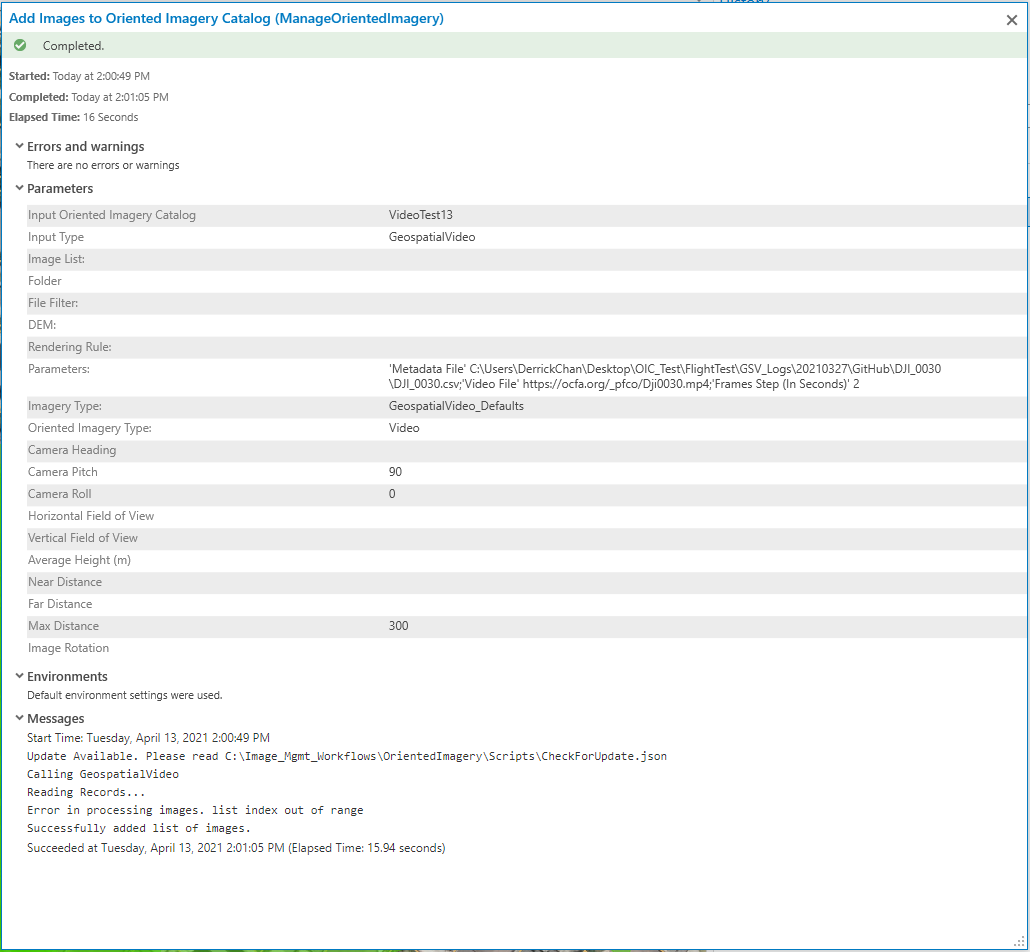
Thanks for the reply and for uploading the user doc! I believe my original issue was due to not having been logged into ArcGIS Online while running the Add Images to Oriented Imagery Catalog tool. After signing in and then running the tool, I see that my Exposure Points table is now populated with records. However, I'm encountering another issue as my Coverage Map table still remains empty.
After the Add Images tool runs, I see the following messages:

As requested, here is my metadata file:
DJI_0030.zip
And here is the link to my video just in case it helps with further testing:
http://ocfa.org/_pfco/Dji 0030-1_Multiplex.mp4
By the way, I have downloaded and installed the newest release of the Oriented Imagery Management Tools (v2.6)
I really appreciate your help with this, thank you!
from oriented-imagery.
RandallRebello
commented on June 12, 2024
@derrickocfa
Thanks for sending me the sample file. I realize the problem.
There is an extra line at the end of your sample file that is creating this issue.
Open it up in the text editor (not excel) and delete the bottom most blank line.
I'll work on a fix and update. Till then you can try it out by removing the line.
However, I'm encountering another issue as my Coverage Map table still remains empty.
After adding the records.. run Create Coverage Features and then Create Coverage Map.
Randall
from oriented-imagery.
derrickocfa
commented on June 12, 2024
Hi @RandallRebello,
My bad about the coverage features and map. I should have read ahead in the documentation! I was able to generate them successfully.
I removed the carriage return from my metadata csv file but I'm still encountering the same issue:

When I try to view the OIC with the Oriented Imagery Viewer in Pro, the loading symbol appears but just hangs

Do you think the issue could perhaps be with my video file?
Thanks,
Derrick
from oriented-imagery.
 kushu493
commented on June 12, 2024
kushu493
commented on June 12, 2024
Hi Derrick,
There is some issue with your video file. Even the browser cannot play the video.
Thanks
Kushagra
from oriented-imagery.
derrickocfa
commented on June 12, 2024
Hi @kushu493,
Does the uploaded video file need to be the multiplexed video? I was having trouble trying to get that file to play in the browser. However, when I uploaded a copy of the video file that I had before multiplexing it, the video file plays just fine.
I've tried running the Add Images to Oriented Imagery Catalog tool with the URL for the new video file but I still receive the 'Error in processing images. list index out of range.' message

Here's the url to the new video file if it helps with testing:
https://ocfa.org/_pfco/Dji0030.mp4
I also double checked my csv to make sure the carriage return was removed just like @RandallRebello recommended.
Thank you!
Derrick
from oriented-imagery.
kushu493
commented on June 12, 2024
Hi Derrick,
It worked now. I was able to view the video in Oriented imagery viewer.
See the link - https://oi1.img.arcgis.com/app/index.html?oic=80f3673b5c7c4d18b935891748b2d4ef
Try to create catalog using this .csv file
DJI_0030.zip
Thanks
Kushagra
from oriented-imagery.
derrickocfa
commented on June 12, 2024
Hi Kushagra, thanks for getting back so quickly. I tried the csv file you sent and still no luck being able to add images to the catalog successfully. It's interesting that you're able to create one just fine on your end with the data I've provided when I'm unable to. When you ran the Add Images to Oriented Imagery Catalog tool, did your parameters look different from this?
Thanks,
Derrick
from oriented-imagery.
kushu493
commented on June 12, 2024
Hi Derrick,
Apart from Frame Step which is 1 in my case, rest of the parameters are same. I tried with Frame step = 2, and still it worked.
@RandallRebello can you please see why "Add images to Oriented Imagery tool" does not work for Derrick. Note - I am able to create OIC from the .csv file that I shared with Derrick.
Thanks
Kushagra
from oriented-imagery.
RandallRebello
commented on June 12, 2024
Hi Derrick,
This is a bug in the code. It looks like the is a blank line at the end of your CSV file. You need to edit it in a text editor and remove this blank line.
I am working on a fix for it.
Randall
From: derrickocfa ***@***.***>
Sent: Wednesday, April 14, 2021 1:31 AM
To: Esri/oriented-imagery ***@***.***>
Cc: Randall Xavier Rebello ***@***.***>; Mention ***@***.***>
Subject: Re: [Esri/oriented-imagery] Geospatial Video OIC (#45)
Hi Kushagra, thanks for getting back so quickly. I tried the csv file you sent and still no luck being able to add images to the catalog successfully. It's interesting that you're able to create one just fine on your end with the data I've provided when I'm unable to. When you ran the Add Images to Oriented Imagery Catalog tool, did your parameters look different from this?
[image][user-images.githubusercontent.com]<https://urldefense.com/v3/__https:/user-images.githubusercontent.com/17831636/114623864-b149d280-9c64-11eb-8ca2-6f236bd7c02f.png__;!!CKZwjTOV!he4WF5BpFWb11OSSa36BZlr7LBhgSUrTxwzmEgjTsN6-R8wY-a23igRGu5t2$>
Thanks,
Derrick
—
You are receiving this because you were mentioned.
Reply to this email directly, view it on GitHub [github.com]<https://urldefense.com/v3/__https:/github.com/Esri/oriented-imagery/issues/45*issuecomment-819067769__;Iw!!CKZwjTOV!he4WF5BpFWb11OSSa36BZlr7LBhgSUrTxwzmEgjTsN6-R8wY-a23igXduOsZ$>, or unsubscribe [github.com]<https://urldefense.com/v3/__https:/github.com/notifications/unsubscribe-auth/AAYRAB2B5EA6Q6GZG3F5ZBTTISZZFANCNFSM42H5KYWQ__;!!CKZwjTOV!he4WF5BpFWb11OSSa36BZlr7LBhgSUrTxwzmEgjTsN6-R8wY-a23ilE6RS9s$>.
from oriented-imagery.
derrickocfa
commented on June 12, 2024
Hi @RandallRebello,
I removed the blank line in my CSV a few days ago when you had originally brought it to my attention but I'm still receiving the "Error in processing images. list index out of range" message. I also tried the CSV that @kushu493 provided - which was used to successfully add the video to the OIC - but I still receive the same message when running the tool. Is there something else that I could be missing that is causing Add Images to Oriented Imagery Catalog to not complete successfully? I am on Pro v2.7.3 (though I was receiving the same error message at 2.7.2) and have installed the Oriented Imagery Management Tools (v2.6) and Oriented Imagery add-in for ArcGIS Pro (v2.6). Thanks for your help!
-Derrick
from oriented-imagery.
RandallRebello
commented on June 12, 2024
@derrickocfa Can you please check it now. I made a fix for this.
from oriented-imagery.
derrickocfa
commented on June 12, 2024
@RandallRebello thank you for updating the python script, the tool completes successfully now! Big thanks to you and @kushu493 for helping me with this!
PS - I'm not sure if you're the right person to notify for this but the OIC Viewer in ArcGIS Pro doesn't seem to want to play the video. However, I was able to publish the OIC to ArcGIS Online and everything seems to be working in the OIC web app which was my goal all along. Just thought I should let someone know
Thanks,
Derrick
from oriented-imagery.
kushu493
commented on June 12, 2024
Hi Derrick,
Currently, we do not support video in ArcGIS Pro add-in tool. Video is currently only supported on the web.
Thanks,
Kushagra
from oriented-imagery.
derrickocfa
commented on June 12, 2024
Hi Kushagra,
It's funny that you mention that. I found that when I converted the video file type to .webm, it will play in the OIC Viewer add-in tool in Pro. I am, however, unable to play the video with the 2D widget in Web AppBuilder (neither .mp4 nor .webm will work). The 3D version seems to work fine though. I saw that 2D has been deprecated in lieu of support for an OIC widget in an upcoming release for ArcGIS Experience Builder. Any chance you have an estimate for when that might become available?
Thanks,
Derrick
from oriented-imagery.
kushu493
commented on June 12, 2024
Hi Derrick,
In OIC viewer add-in tool, we use chromium to display the viewer. Chromium does not support all the video codecs that google chrome supports. .webm format is supported by HTML as default. That's why it works.
2D widget is deprecated and has not been updated in past 2 years. Please don't use it to create apps.
Experience Builder widget will be released next week.
Thanks,
Kushagra
from oriented-imagery.
 abhiataero
commented on June 12, 2024
abhiataero
commented on June 12, 2024
@derrickocfa The Experience Builder Widget has been release.
I am also closing this issue, i have created a new issue for supporting video in ArcGIS Pro Addin #53
from oriented-imagery.
Related Issues (20)
- Add Support to play video files in ArcGIS Pro Oriented Imagery Addin
- WAB Widget: Image is not displayed if the point of interest intersects with any vector layers
- Drone2Map oictype is an invalid json file.
- Update widgets for 2.7 release
- error in https://oi.geocloud.com/api/v1.1/js/viewer.js
- Create Coverage Features reports missing properties one at a time
- Include support for ArcGIS Pro 2.8.2 HOT 1
- error when re-publishing catalog HOT 2
- OI gptool call from python script
- Geospatial Video Fixes
- Oriented Imagery with Quick Capture and Experience builder
- 2D and 3D Apps do not pick up OIC in root folder in ArcGIS Enterprise
- Video does not play in OIC experience builder widget
- When we open 360 images in oriented imagery viewer ,it open up in random direction, let say we want all photos for a particular distance to be open in East direction , how can we do that.
- Experience Builder Widget - set overflow to hidden on scroll bar HOT 2
- Update OrientedImageryCatalog_Schema.pdf
- integration of oriented imagery API
- Setting Property node in OI.xml config file
- Camera location - green dot alignment issue
- OI scene view issu
Recommend Projects
-
 React
React
A declarative, efficient, and flexible JavaScript library for building user interfaces.
-
Vue.js
🖖 Vue.js is a progressive, incrementally-adoptable JavaScript framework for building UI on the web.
-
 Typescript
TypeScript is a superset of JavaScript that compiles to clean JavaScript output.
-
TensorFlow
An Open Source Machine Learning Framework for Everyone
-
Django
The Web framework for perfectionists with deadlines.
-
 Laravel
A PHP framework for web artisans
-
D3
Bring data to life with SVG, Canvas and HTML. 📊📈🎉
-
Recommend Topics
-
javascript
JavaScript (JS) is a lightweight interpreted programming language with first-class functions.
-
web
Some thing interesting about web. New door for the world.
-
server
A server is a program made to process requests and deliver data to clients.
-
Machine learning
Machine learning is a way of modeling and interpreting data that allows a piece of software to respond intelligently.
-
Visualization
Some thing interesting about visualization, use data art
-
Game
Some thing interesting about game, make everyone happy.
Recommend Org
-
Facebook
We are working to build community through open source technology. NB: members must have two-factor auth.
-
Microsoft
Open source projects and samples from Microsoft.
-
Google
Google ❤️ Open Source for everyone.
-
Alibaba
Alibaba Open Source for everyone
-
D3
Data-Driven Documents codes.
-
Tencent
China tencent open source team.
from oriented-imagery.