Comments (7)
 kfjahnke
commented on June 11, 2024
kfjahnke
commented on June 11, 2024
ping! Anybody out there?
from openexr.
 peterhillman
commented on June 11, 2024
peterhillman
commented on June 11, 2024
I think the lack of response indicates how few people understand that diagram, but yes I think it's a typo in the text and positive X should be right not left
from openexr.
kfjahnke
commented on June 11, 2024
few people understand that diagram
you're kidding. everyone doing 3D geometry must understand which way their axes point.
I am currently working my way into environment formats, bot lat/lon and cubemap, and their representation as openEXR and OIIO understand them. I assume (!) that OIIO uses openEXR axis semantics, but I'm not sure. When I access a lat/lon environment using OIIO's 'environment' function (the access is via 3D directional vectors), the axis order which works for me is this (quote from my program envutil
// openEXR uses different 3D axis semantics, and if we want to use
// OIIO's environment lookup function, we need openEXR 3D coordinates.

// Here's what the openEXR documentation sys about their axis
// order (next to a drawing which says differently, see this issue:
// https://github.com/AcademySoftwareFoundation/openexr/issues/1687)

// quote:
// We assume that a camera is located at the origin, O, of a 3D
// camera coordinate system. The camera looks along the positive z
// axis. The positive x and y axes correspond to the camera’s left
// and up directions.
// end quote

// so we'd get this axis order, assuming they store x,y,z:

enum { EXR_LEFT , EXR_UP , EXR_FORWARD } ;

// the cubemap comes out right this way, so I assume that their text
// is correct and the drawing is wrong.
so my conclusion is just the opposite: the diagram is wrong and the text is right. There must be people at openEXR who can say what's right, hence the ping.
from openexr.
 meshula
commented on June 11, 2024
meshula
commented on June 11, 2024
The OrientationCube.exr file that we distribute is correct. If you position a camera in the center of an environment mapped with it and look around, you should see the axis indicated in each face (+x, -x, etc) in the expected direction, and the little axis images should also be oriented as expected. I don't think this helps you with the question you are asking but I personally use the observable behavior as a ground truth, and the reference to OpenImageIO face ordering in relationship to the OpenEXR documentation diagram is confusing to me :)

The picture you are referring to is this one.
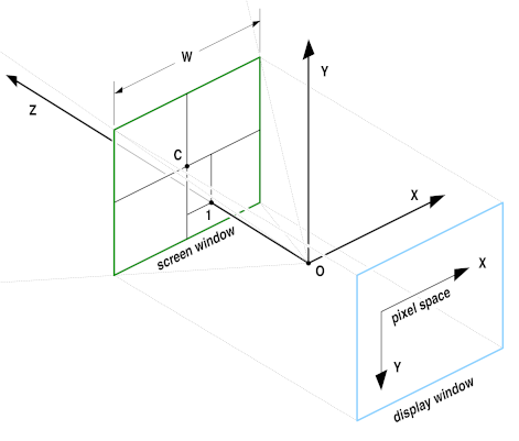
If we are inside the cube looking at the faces, with a camera that looks down the NEGATIVE axis (even though the text says the camera is looking down the POSITIVE axis), then cube faces work as expected.
My opinion is that in the cubemap case, that diagram is doing too much work with too little context, and I'm not sure we can reconcile that image with what the text is trying to say about planar images with the facts about cube maps simultaneously, without making things worse. I think we need another diagram for cube maps using the strip map I posted above mapped on to a cube to unambiguously illustrate how it works.
Furthermore, latlong images are also meant to be environment mapped. I think we would be overburdening that image of a planar projection to try to say meaningful things about latlong environment maps, and so there should be another image, using the the cube strip remapped to latlong to show how things work when the camera is at the center of the projection. Furthermore, the diagram should show where 0,0 in the 2d image is so that one may know how the latlong image is rotated about the polar axis.
If I had time I would create these images, but perhaps someone besides me might undertake some improvements.
from openexr.
kfjahnke
commented on June 11, 2024
If we are inside the cube looking at the faces, with a camera that looks down the NEGATIVE axis (even though the text says the camera is looking down the POSITIVE axis), then cube faces work as expected.
If you're changing the sign on the z axis, the x axis goes the other way, and the y axis is not affected. This is just the same as changing the sign on the x axis. The two are linked - you can't change only one of them, whereas the y axis 'stands by itself'. This is what you see when converting between polar and cartesian coordinates: to produce the azimuth, you need a sine and a cosine term. The elevation only needs a cosine. So changing the sign on the x or the z axis is just the other side of the same coin.
We can agree on the fact that the diagram is wrong. I think the diagram could be stripped down to the essential to clarify openEXR axis semantics - if you need a diagram at all for that: the text is sufficient, and the diagram (wrong as it is) only confuses matters.
Thanks for clarifying, @meshula - we've had a bit of discussion already in this issue, and I've made some progress towards writing a new tool to convert between lat/lon and cubemap formats - maybe you've had a look at the link to envutil I gave in my previous post. This was mainly fun, with an issue in OIIO which needed setting straight, but otherwise it was a good way to 'exercise' may library zimt to code the conversions in multithreaded SIMD code, and the program is coming as a zimt example program. I think it does pretty much the same thing which exrenvmap does, but with the 'better mathematics' you thought should be applied. For environment lookup, it uses OIIO's texture system code, which uses an anisotropic antialiasing filter steered by the derivatives of the transformed coordinates. That's the default - it can also use fast bilinear directly on the source data. Have a look!
from openexr.
meshula
commented on June 11, 2024
Nice to see the final result of envutil, nice way to wrap up that thread :)
I was thinking about the diagram some more, and started wondering why the camera is in the diagram at all. I think "Projection, camera coordinate system and screen window" refers to the standard attributes in the EXR file, and I have a feeling that originally OpenEXR might have been more tied to a camera model. If the diagram is that, we should definitely say so, and name the attributes being illustrated. A further problem, if it's an attribute explanation, is that we've revised and clarified the standard attributes and I don't have a memory of us reviewing the diagram to make sure it still agrees with the standard attributes.
from openexr.
kfjahnke
commented on June 11, 2024
Nice to see the final result of envutil, nice way to wrap up that thread :)
I carried on with this project - envutil is now quite complete and has several options to do the environment/texture lookup, among them OIIO's sophisticated lookup code, and my own invention: 'twining', in-lined supersampling and subsequent weighted pixel binning. Then I decided to add a second program 'extract' which can produce reprojected/cropped images from a lat/lon or cubemap environment. This has now reached a 'presentable' stage as well, and today I've uploaded an experimental debian package. Documentation is on the github project page.
from openexr.
Related Issues (20)
- About 3.2.126 release HOT 7
- exrenvmap: observed imprecise conversion of cubemap to lat/lon HOT 11
- Provide an API using numpy arrays in python HOT 11
- An integer overflow in file exrmultipart.cpp HOT 3
- Incorrect Values When Reading DWA Compressed Layer With OpenEXRCore HOT 10
- tarball at https://github.com/AcademySoftwareFoundation/openexr/releases/download/v3.2.4/openexr-v3.2.4.tar.gz extracts incorrectly HOT 3
- Python crashes when trying to write an output file HOT 2
- Is there any way to write a bigger image?
- [Need suggestions/recommendations] OpenEXR for high-speed images grabbing application scenario. HOT 7
- update metadata without rewriting the entire file HOT 4
- Bazel install target HOT 9
- fatal clang-format error on macOS can't upgrade/install via Homebrew HOT 13
- Cross-compiler target linking failure HOT 1
- Uninitialized sliceOptimizationData::type HOT 2
- [Usage recommendation request] Decompressing large EXRs in real-time. HOT 4
- OpenEXR.OutputFile Fails to Write to BytesIO Buffer HOT 1
- Install openexr 3.2.4 to macOS Big Sur 11.7.10 HOT 8
- Unit tests fail when building UB2 binaries on Mac. HOT 1
- CMP0107 issue
Recommend Projects
-
 React
React
A declarative, efficient, and flexible JavaScript library for building user interfaces.
-
Vue.js
🖖 Vue.js is a progressive, incrementally-adoptable JavaScript framework for building UI on the web.
-
 Typescript
TypeScript is a superset of JavaScript that compiles to clean JavaScript output.
-
TensorFlow
An Open Source Machine Learning Framework for Everyone
-
Django
The Web framework for perfectionists with deadlines.
-
 Laravel
A PHP framework for web artisans
-
D3
Bring data to life with SVG, Canvas and HTML. 📊📈🎉
-
Recommend Topics
-
javascript
JavaScript (JS) is a lightweight interpreted programming language with first-class functions.
-
web
Some thing interesting about web. New door for the world.
-
server
A server is a program made to process requests and deliver data to clients.
-
Machine learning
Machine learning is a way of modeling and interpreting data that allows a piece of software to respond intelligently.
-
Visualization
Some thing interesting about visualization, use data art
-
Game
Some thing interesting about game, make everyone happy.
Recommend Org
-
Facebook
We are working to build community through open source technology. NB: members must have two-factor auth.
-
Microsoft
Open source projects and samples from Microsoft.
-
Google
Google ❤️ Open Source for everyone.
-
Alibaba
Alibaba Open Source for everyone
-
D3
Data-Driven Documents codes.
-
Tencent
China tencent open source team.
from openexr.